History of the Proto-Bulgarians (2)
Unogundurs, Kuban, kureni, auli, Great Bulgaria, Phanagoria
Documentary sources attest that at the end of the IV c. - V c. AD a part of the Unogundurs-bulgars (vh’dur-bulgar), previously inhabiting the region of the eastern Fore-Caucasus known as ‘Land of the Bulgars’, moved westward and occupied the low lands of the river Kuban along the north-eastern Black Sea coast and the eastern coast of the Sea of Azov (Meotida). The V-VI century authors located there the Unogurs, and Procopius and his successors in the mid-VI c. - the Utigurs. Contrary to the Dagestan Bulgars, who started to settle down comparatively early, their compatriots in the eastern Meotida continued the life of nomads till VII c., which makes more difficult the recovery of their material remains. In 1947 a necropolis near stanitsa Novo-Labinskaja in the middle course of Kuban was investigated . The graves exhibit many details characteristic for the Dagestan Bulgars - narrow, oriented to the north pits, with virtually no artefacts (which make difficult a more exact dating), and artificial skull deformation in some cases. The investigator Nechaeva
[1] attributed this uncharacteristic for the earlier inhabitants of that region necropolis to penetrated in IV-V c. from the east nomadic tribes, which later formed to the Kuban Proto-Bulgarians.
Another necropolis which, on the basis of the anthropological data and the ways of burial, can be attributed to the Proto-Bulgarians is that near the resort village of Borissovo, ten kilometres to the north of the town of Gelendzhik. A half of the 135 graves contain inhumations, the rest - cremations, the two types being separated in different parts of the common necropolis. Very characteristic is that the body remains were put in cameras built of rock slabs. The northern orientation is predominant, all burials are individual, contrary to the collective Alan burials, and are relatively rich in objects accompanying the dead - dress accessories, pottery, sometimes weapons (axes, swords, arrows, etc.).
The excavator V.V. Sahanev
[2] dated the Borissovo necropolis to the VI-VIII c. while the modern investigators accept its existence till the beginning of the IX c. M.I. Artamonov attributes the Borissovo necropolises to the Goths-tetraksites who were neighbours of the Utigurs, but it is well known that those Goths were Christians since the IV-V c. and consequently that pagan necropolise could not be their work.During the early stages of functioning of the necropolis the graves with inhumations were predominant, while later the share of the cremations apparently increased
[3].
The inhumation burials with their primitive sarcophagus-like cameras of rock slabs and the accompanying the dead objects (amphora-like pottery, belt ornaments) show great similarities with a numbers of pagan necropolises from the Lower Danube, especially from the eastern part of north-eastern Bulgaria and Dobrudzha
[4]. Other similar to the above are the Pashkovski necropolise near the city of Krasnodar and the necropolise at the river Djursju, near the city of Novorossijsk.
As it was already mentioned, the nomadic life of the Proto-Bulgarians left scarce material remains, but thanks to the long and patient work of Pletnjova
[5], we have some idea about their life and social structure. The archaeological investigation of great areas along the eastern and western coast of the Sea of Azov and the lower Don basin revealed that the earliest traces of the Proto-Bulgarians (pottery fragments, bones of domestic animals) are confined to a narrow (50-300 metres wide) strip of land along these basins. The finds are very scattered, sometimes 3-5 pieces of pottery or bone per one kilometre. No cultural layer could be found, pointing to the mobile character of the nomadic camps, founded on a different place each spring after the migration of the flocks. 70% of the pottery fragments represent amphorae, speaking about active Proto-Bulgarian contacts with Crimea and Byzantium since the VI c. The amphora fragments are also the best tool to date the phases in the development of the Proto-Bulgarian society - from a nomadic life to a settling down in permanent dwellings. With the time some camps were transformed in seasonal, and later - in permanent dwellings. These seasonal camps (
kureni) were quite large - 1.5 km x 0.2-0.3 km and were inhabited by several hundred families.
Later, since the VII c. on, the camps were reduced in size to accommodate only 20-30 families, reflecting the social and economical changes - the differentiation of enriched families who, together with their poor relatives, parted from the kureni to form smaller
auli. The economical organisation of auli, as well as additional factors (the Khazar expansion, the Arab-Khazar wars), contributed to a further impoverishment of a significant part of the Proto-Bulgarian population. The deprived of their cattle nomads had to look for new means of support - agriculture and crafts, and to settle down more or less permanently. Thus in the VIII-IX c. some of these small auli were transformed in permanent villages. Another factor facilitating that process was the Proto-Bulgarian conquest of several urban centres as Phanagoria and Kepi as early as the first half of the VI c.
[6]. Byzantine amphorae are always found, even in the most remote mobile camps. Favourable for the creation of permanent villages conditions appeared at the end of the VI c. and in the first half of the VII c. when the Azov Proto-Bulgarians under the leadership of Khan Kubrat shaked off the yoke of the Turcuts and created the military tribal union Great Bulgaria
[7].
It was quite probable that they had utilised some of the conquered antique centres on the coast. After the WWII Soviet historians, using the documentary sources and accepting the proposition of the prominent Russian armenist Patkanov that Khan Kubrat was buried in Phanagoria, advanced the hypothesis that this city, situated on the Taman peninsula on the coast of the Straits of Bosporus, was the capital of Great Bulgaria
[8]. The subsequent archaeological excavations indeed revealed that at the end of the IV c. the flourishing by then city was destroyed by the Huns. In V-VI c. its population left virtually no traces, and Phanagoria was revived back to life only in the second half or even at the end of VII c, that is, after the break up of Great Bulgaria and the conquest of the eastern Azov lands by the Khazars
[9]. At the end of the VII c. Phanagoria was one of the most important administrative and military centres of the Khazar khaganate, which during the years 698-704 gave refuge to the dethroned Byzantine emperor Justinian II.
The fact that up to now in Phanagoria no unequivocal Proto-Bulgarian artefacts were found makes Pletnjova think the Proto-Bulgarians did not ‘master’ the city, but rather used it as an intermediate for their commercial contacts with Byzantium and the cities in Crimea.
Similar to that of Phanagoria was the fate of the other important urban centre on the Taman peninsula - the Taman gorodishte (the antique Hermonasa, the medieval Tamatarkha-Tmutorokan). In its thin V-VI c. cultural layer there are no Proto-Bulgarian artefacts. Only during the VII c. hand-made pottery characteristic for the Proto-Bulgarian camps along the Sea of Azov and the lower Don, started to appear, and it evidences the VII-VIII c. significant influx of Proto-Bulgarians
[10].
---------
Thus in the VI-VII c. the Proto-Bulgarian population east of Azov generally preserved its nomadic way of life and primitive material culture. Their contacts with the Black Sea cultural centres were reduced mainly to the acquiring of the necessary agricultural and craft products. Quite probable is, however, the early settling down of some Proto-Bulgarian, especially along the Black Sea coast. To such groups probably belong at least part of the graves with inhumations at Borissovo, at the river Djursju, at the Artuganov, Pashkov and Jasenopoljanskij necropolises. These of them which were studied anthropologically, contain artificially deformed skulls.
The necropolises with northern orientations of the graves (at Novolabinka, Artuganovi, Borissovi) are similar to Proto-Bulgarian necropolises of Northern Dagestan and confirm the ethnic unity of the population in the eastern and western fore-Caucasus (Unogundurs-bulgars). At the same time, necropolises with the same burial artefacts and the characteristic artificial skull deformation, but with western orientation of the graves (at Pashkov, Jasenovopoljanov) have to be attributed to another Proto-Bulgarian tribe, most probably to the mentioned in the Armenian geography Kupi-Bulgars.
References: [1] L.G. Nechaeva. Ob etnicheskoj prinadlezhnosti podbojnyh i katakombnyh pogrebenij sarmatskogo vremeni v Nizhnem Povolzh’e i na Severnom Kavkaze. s.158.
[2] V. Sahanev. Raskopki na Severnom Kavkaze v 1911-1912 godah. - Iizvestija Imperatorskoj arheologicheski komissii, vyp. 56, Petrograd, 1914, s.77-78.
[3] V.B. Kovalevskaja. Severokavkazkie drevnosti. - V: Stepi Evrazii (Arheologija SSSR). M., 1981, s.93.
[4] D. Il. Dimitrov. Pogrebalnijat obred pri rannobylgarskite nekropoli vyv Varnensko (VIII-IX v.) - IAI, XXXIV, 1974, s.52-92.
[5] S.A. Pletnjova. Ot kochevij k gorodam. Saltovo-Majckaja kul'tura. - Materialy i issledovanija po arheologii SSSR, 142, 1967, s. 13-15; Nomadski poselishta prez VII-IX v. v Priazovieto i basejna na reka Don. - Arheologija, VI, 1964, kn. 4, s.1-2.
[6] Procopii Caesariensis. Libri de bellis VIII, p.508.
[7] V. Zlatarski. Istorija na bylgarskata dyrzhava prez srednite vekove, S., 1970, I, 1. s.130-175.
[8] A.P Smirnov. V: Istorija SSSR s drevnejshih vremen do nashih dnej. Tom I, M., 1966, s.331.
[9] S.A. Pletnjova. Drevnie bolgary v bassejne Dona i Priazovjja. - Sb. Pliska-Preslav, 2. S., 1981, s.16.
[10] S.A. Pletnjova. Srednevekovaja keramika Tamanskogo gorodishta. - V: Keramika i steklo drevnej Tmurtarakani, M., 1963, s.10,14,63-64.
Kutrigurs, Severski Doneck, Zlivka necropolis, Sarkel
The documentary sources indicate that the steppe regions west of the river Don, along the northern coast of the Black Sea and the Sea of Azov, were populated in the VI-VII c. AD by the Bulgars-Kutrigurs. They were akin to the Proto-Bulgarians of the eastern Azov and lived under similar social and economic conditions. The information of Procopius and Agathius reveal that they were nomads, to whom the wars and the plunder were the main way of acquiring of luxury goods and agricultural goods. However, since the mid-VI c., under favourite conditions, they tended to to settle down. Indicative is the fact that after being defeated by the Utigurs, 2000 Kutrigurs, led by Sinion, settled in Thracia as Byzantine subjects during the reign of emperor Justunian
[1]. Because of their nomadic way of life, there are no visible traces left from the Kutrigurs. Pletnjova's investigations along the northern coast of the Taganrog bay show a picture, similar to that from the eastern Azov - temporary camps with few artefacts, concentrated around the steppe rivers' mouths
[2]. There are no necropolises found from that period, but from the later period - VIII-IX c., there are more than 20 necropolises and isolated graves
[3].
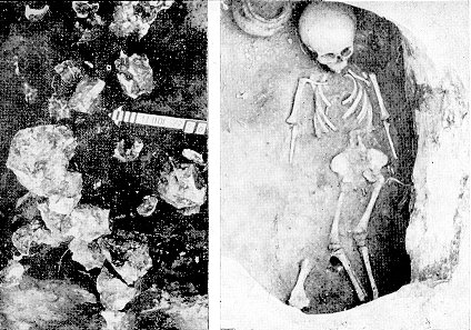
Unfortunately, the data for the Proto-Bulgarian necropolises are incomplete, for most of them we have only brief messages. The 'classical' Proto-Bulgarian necropolis at Zlivka, however, reveals the main features of these complexes. The Zlivka necropolis is situated at the middle course of the river Severski Doneck, near the village of Ilichevska. The burials are in shallow pits (0.6-1.0 m), with simple vertical faces and no signs of niches, step-like widenings or covers of any kind. The dead were laid directly at/on the ground. All graves are single, of western-eastern orientation (the head points to the west). The accompanying objects are few - one or two pots and animal bones. Weaponry and instruments of productions are not present at all. The buried were brahiochranic with barely detected Mongoloid signs
[4].
These features are characteristic for almost all necropolises in the region, where the western orientation, the general scarcity of the burial objects and the brachiochranic anthropological type predominate. There are some deviations in the way of burial, for example, in several graves from the pit necropolis at Sarkel, and in one burial in the catacomb necropolis at Dmitrievka the pit is circular in shape. In isolated cases in the same two necropolises there are niches. And contrary to the predominant western orientation of the common pit burials, these with niches are south-north oriented (the head points to the south). The orientation is also unstable in the late burials in necropolises found next to large settlements, such as the Semikarakorskoe gorodishte and the fortress of Sarkel.
Another peculiarity is the presence of primitive sarcophaguses - rock slabs along the pit faces. They are especially common for the necropolis of the Rigin gorodishte, near the town of Kamensk-Shahtinsk on the lower course of Severski Doneck. Similar burial structures are characteristic for the Proto-Bulgarian necropolises of Crimea
[5]. This fact made some researches suggest that that feature attests a migration from Crimea to the region of Severski Doneck and Lower Don rivers
[6], but their proposition cannot be accepted, because some necropolises, such as the Rigin necropolis, are older than the Crimean ones and furthermore - such constructions are widely spread. In some cases the rock slabs are substituted by wooden planks, or a wooden trough, covered by a wooden plank. The function of all these constructions is the same - the close the dead, to isolate him from the living. The niches (the necropolis at Zholtoe) serve the same purpose.
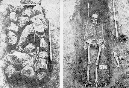
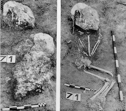
The idea of confining the dead or rather, his spirit, within the grave and to prevent him from harming the living people, is implemented in various ways: binding the legs (Volokonovski and Dronovka necropolises), pressing down the body with stones (Zholtoe, Dronovka necropolises), ritual amputation of the feet (Majack gorodishte necropolis).
-----------
The archaeological data show that in the steppe regions north of the Black Sea and the Sea of Azov in the VI-VII c. were occupied by a homogeneous ethnical group. Some necropolises, indeed, show deviations from the 'classical' Zlivka type of burial, but it must be stressed that these cases come from comparatively late finds, and that at least some of them reflect the sizeable displacements of Proto-Bulgarian tribal groups after the Khazarian invasion and the Khazaro-Arab wars of the second half of the VII c. and the first half of the VIII c. The results of these displacements are most clearly seen in the border regions between the different Proto-Bulgarian groups. The necropolis of such a large centre as Sarkel shows significant deviation in the burials, affecting even the orientation. It is both western and northern
[7]. Northern orientation is also found in other places along the eastern bank of the Don river (Artuganov necropolis, Semikarakorskoe gorodishte, at the mouth of the river Manuch).
Generally, the anthropological type and burial practices of the population north of the Black Sea were similar to that of the Unogundur-Bulgars from the eastern Azov. The main difference is in the orientation of the graves - northern for the Unogundurs and western for the Proto-Bulgarians north of the Black Sea. Besides that, the artificial skull deformation was widely spread among the Unogundurs but was virtually unknown to the Proto-Bulgarians north of Meotida. The border between these two Proto-Bulgarian groups was the Sea of Azov and the Lower Don. According to Procopius, it was exactly Azov and Don, which in the mid-VI c. separated the Kutrigurs from the akin to them Utigurs. Thus the archaeological evidence confirms the documentary one.
References: [1] Procopii Caesariensis Libri de bellis VIII, p. 586, 637.
[2] S.A. Pletnjova. Ot kochevij k gorodam, s. 16-18;
Nomadski poselishta prez VII-IX b. ..., s. 3-5.
[3] S.A. Pletnjova. Drevnie bolgarii v bassejne Dona i Priazov'ja, s. 9-11;
Vostochnoevropejskie stepi vo vtoroj polovine VIII-X v. - V: Stepi Evrazii v epohu srednevekov'ja (Arheologija SSSR), s. 70-71.
[4] G.F. Debec. Paleoantropologija SSSr. - trudii instituta etnografii (novaja serija, t. IV, M., L, 1948, s. 253-256, tabl. 106 i ris. 102;
K.N. Nadzhimov. O cherepah Zlivkinskogo mogil'nika - Kratkie Soobshtenija Instituta Etnografii AN SSSR, viip. 24, M., 1955, s. 55.
[5] A.L. Jakobson. Rannesrednevekoviie sel'skie poselenija Jugo-Zapadnoj Tavriki. - Materialii i issledovanija po arheologii SSSR, 168, 1970, s. 133-140.
[6] S.A. Pletnjova. Drevnie bolgarii ..., s. 12.
[7] S.A. Pletnjova. Drevnie bolgarii ..., s. 10-11.
"Old Great Bulgaria"
In the VI c. the northern and the eastern coast of the Sea of Azov was occupied by two large Proto-Bulgarian groups, still living nomadic life under the tribal system. The lower course of the river Don served as a boundary between them. The campaigns for plunder from the first half of the VI c. contributed to a further social differentiation in the society and to a strengthening of the economical and political power of the tribal aristocracy. The letter of the Utigur leader Sandilkh to emperor Justinian reveals that the nomads were already seeking to settle down and to use the advantages of the settled life
[1]. The mid-VI c. evidences a process of consolidation of the various Proto-Bulgarian and akin to them groups and the creation of larger formations such as the Kutrigur and Utigur confederations. But the process of unification did not proceed further, on contrary - there were bloody wars between the two confederations. Weakened, the Kutrigurs and, partly, the Utigurs were conquered by the Avars in 558 AD, and in 576 AD the Utigurs fell under the sway of the Turcuts. The foreign yoke provoked a liberation movement, headed by the leader of the Unogundurs-Bulgars khan Kubrat. The successful end of the struggle led to the creation of a tribal union, known to the medieval authors as 'Great Bulgaria'. The documentary data about Great Bulgaria are very scarce and contradictory, giving rise to debates, continuing and nowadays. The eminent Bulgarian historian V. Zlatarski, using the data of the Old Bulgarian 'List of the Bulgarian Khans', dated Kubrat's ascension to power to 584 AD
[2]. Indeed, in the beginning of the 80's of the VI c. the West Turcut Khaganate was torn by a fierce internecine war which diverted Turcut's attention from Eastern Europe and facilitated the subjugated peoples in their drive for freedom
[3]. Byzantium seized the opportunity and retook the Crimean city of Bosporus (today's Kerch), taken earlier by Turcsant. The Ugrs also threw off the Turcut domination. The Soviet scholar M. Artamonov, however, rejects such an early date for the formation of Great Bulgaria, pointing out that after the end of the civil war in 593 AD Turcuts defeated again the Ugrs and reasserted their authority over the previously conquered territories (except Bosporus)
[4]. According to Artamonov, much more likely is the appearance of Great Bulgaria to have taken place in the 30's of the VII c., when the Turcut Khaganate plunged in one even more violent civil war, stripping it forever from its European possessions. In any case, not later than 635 AD, when the Proto-Bulgarians under the Avars also got free, Great Bulgaria was already into being with khan Kubrat as its leader
[5]. According to the List of the Bulgarian Khans Kurt (Kubrat) reigned for 60 years, post probably from 580-590 AD till his death in mid-VII c.
Highly debatable are the borders of Kubrat's union. The data come from the brief and often confused notes of the Byzantine chronicler Theophanes the Confessor (end of VIII c. and beginning of IX c.), complemented by his contemporary Patriarch Nicephorus and the Armenian geography from the VII c. Theophanes writes:
"It is necessary to mention the past of the Unogundurs-Bulgars and the Kotrags. In the northern parts of the Euxine (Black) Sea, in the so called Lake of Meotida flows an enormous river, called Atel (Volga), descending from the Ocean through the land of the Sarmatians. The river called Tanais (Don), which has its beginning in the Iberian gates in the Caucasus mountains, empties into it (Volga). The jointing of Atel and Tanais creates the river, called Kuphis, which runs into the Pontus, near the Necropiles (the modern Karintski bay, near the south-west coast of Crimea), near the cape called Krioproson (Sheep snout). From the above mentioned lake begins a strait-like sea, running into the Euxine Pontus thought the land of the Crimean Bosporus (the modern Straits of Kerch). The so called fish Murzuli and other similar fish is fished for there, and along the eastern coast of that lake, around Phanagoria and the dwelling there Jews, live many peoples. From the same lake up to the Kuphis river, where the Bulgarian fish xiston is fished for, is situated the old Great Bulgaria and the so called Kotrags, who are also of the same tribe." [6].
Patriarch Nicephorus account is brief: "
We must say something about the origin of the so called Huns and Bulgars and about their way of life. Around the lake of Meotida, along the Kuphis river, is situated the old Great Bulgaria and the so called Kotrags, who are of the same tribe"
[7]. The Armenian geography contains two passages relevant to the position of Great Bulgaria. The first excerpt reads:
"In Sarmatia are situated the Keraunian and the Hipian mountains, where five rivers flowing into the Meotian sea have their sources. Two rivers flow out from Caucasus - Valdanis, from the mountain Krax, which (the mountain) starts in Caucasus and extends to the north-west between Meotida and Pontus. The other river - Psevhros - separates the Bosporus from the lands of the small town Nikops. Northward from this place live the peoples Turcs and Bulgars, who are named after the local rivers: Kupi-bulgar, Duchi-bulgar, Oghontor-blkar - the immigrants, and Chdar-Bolkar. These names are unknown to Ptolomeus. And the son of Hudbadr ran away from the Horse Mountains." [8]
The other excerpt reads:
"In Thracia there are two mountains and rivers, one of which, Danub (Danube) branches out in 6 arms and forms a lake and an island, called Pjuki. On this island lives Haspar-khruk (Asparuh), the son of Hubraat, who ran away from the Khazars from the Bulgarian mountain and who, having driven away the Avars, settled at that place." [9].
The sources are not only brief, but confusing as well. Especially the text of Theophanes, which is the most detailed one. Recently, I. Chichurov made an attempt to trace out the territory of Great Bulgaria by a textual analysis of the information of Theophanes
[10]. He divided the text of Theophanes into two parts - a geographical description of the North Black Sea lands and the Sea of Azov, and an account of the historical facts and the location of Great Bulgaria. Chichurov argued that the two parts are non-equivalent, only the latter, which is similar to the information of Nicephorus, being of historical value, while the former is a later and unnecessary inclusion of confused geographical data which can be discarded. Thus, he concluded the Great Bulgaria was limited to the lands east of the Sea of Azov up to the river Kuban. There are, however, weak points in Chichurov's argumentation. For example, it is not explained why after stating that he will narrate the past of the Unogundurs-Bulgars and the Kotrags, Theophanes proceeds with a description of the lands they inhabit. And here he puts a particular stress on the river Kuphis, which according to him starts at the point where Atel and Tanais join each other, above the lake of Meotida, and after running northward of it, empties in the Black sea near the Necropiles. Theophanes has a clear idea about the exact location of the Necropiles. For example, in his description of the escape of Justinian II from Phanagoria to Bulgaria in 704 AD he correctly states that after passing along the lighthouse of Hersones, the escapee swam across the Necropiles and the mouths of Dnepr and Dnestr
[11]. On another occasion he chronicler locates the river Kuphis next to the Necropiles. Describing the cold winter of 763 AD he remarks that the sea froze along the northern coast of the Pontus and 100 miles inland "from Zinhia to the Danube and to the river Kuphis, Dnepr, Dnestr, Necropiles."
[12] Therefore, the Kuphis of Theophanes is not Kuban, but another river flowing into the Black Sea. As F. Westberg pointed out very early that the Southern Bug river was given the same name by the ancients - Hiphanis, as the river Kuban
[13]. Thus Westberg located Great Bulgaria from the Sea of Azov to the river Dnestr. His argumentation was accepted by Artamonov.
The restriction of Great Bulgaria only to the lands to the east of Sea of Azov meets more difficulties as that land could hardly accommodate the (at least) three tribal groups - the Unogundurs of Batbajan and Asparuh, and the Kotrags. The numerousness of the Proto-Bulgarians is attested in the letter of the Khazarian King Joseph, according to whom the Bulgars were far more humorous than the Khazars, as numerous as the sand in the sea. Furthermore, Nicephorus mentions that in 634-635 AD Kubrat rose against the Avars and drove them away of his land
[14]. The point is that the Avars could not held territories east of the Don river and the Sea of Azov, because these lands were previously a West Turcut's domain, and they were liberated after an uprising of the Unogundurs. Nicephorus' information obviously refers to the Kutrigurs, who inhabited the lands north of the Sea of Azov, from Don to Dnepr and maybe even further westwards. Since 558 AD they were under Avarian political domination, which obviously continued after the withdrawal of the main Avarian forces to Central Europe. The actions of the Proto-Bulgarians of Kubrat were obviously directed against these remains of the Avars. After their defeat, the region north of Azov was incorporated in Great Bulgaria. As both Procopius and Agathius describe exactly the lands north of the Sea of Azov and west of the river Don as the land of the Kutrigurs, the identification of the Kotrags with the Kutrigurs is almost universally accepted. We will not dwell upon the question whether the Kutrigurs were part of the Proto-Bulgarians or an isolated, akin to them tribe.
Thus the Unogundurs-Bulgars lived east of the Azov, and the Kotrags - north, north-west of it, the latter being "of the same tribe" (

). The remarks of Theophanes and Nicephorus that they were close to each other, but not identical, are confirmed by the archaeological data.
 Map of the North Black Sea region.
(The map was produced using XEROX Map Viewer)
Map of the North Black Sea region.
(The map was produced using XEROX Map Viewer)
The western boundary of Great Bulgaria run along the lower course of Dnepr from its firth up to the elbow of the river. Southern boundary was the lower and middle course of Kuban and the mountains of Fore-Caucasus. The northern boundary is most uncertain, reaching probably the region of mixed forest and steppe north and north-west from the Sea of Azov. There is no consensus on its eastern limits. The Armenian geography provides the main reference saying that the son of Hubraat Haspar-Khruk run away from the Khazars from the Bulgarian (Hipian) mountain. It was Patkanov who found that the compiler of the Armenian geography used the data of the ancient geographer Ptolomeus. According to the map of Ptolomeus the Hipian mountain started from the elbow of Volga and run southwards, in the same direction as the ridge Ergeni
[15]. Consequently that ridge and the connected to it Heights of Stavropol were the eastern boundary of Great Bulgaria.
The Proto-Bulgarian group of Asparuh was the first one to face the Khazar expansion and after failing to hold out against the pressure, it had to migrate westwards. The emptied land was incorporated into the ethnic Khazarian territory and the Khazars inhabited it up to the end of the Khazarian Khaganate. Judging from the letter of king Joseph, this territory did not extend to the river Don and was not too extensive. Therefore the Asparuh's domain was located to the east of the lower Don, reaching the ridge Ergeni. The other group of Unogundurs-Bulgars which was under Batbajan did not migrate and had to pay tribute to the Khazarians. The eastern location of the Proto-Bulgarians of Asparuh is confirmed by the archaeological data. The burials in the necropolises north of the Sea of Azov are of western orientation, while those from Proto-Bulgarian necropolises south of Danube (Dobrudja and North-Eastern Bulgaria) are of northern orientation. The same northern orientation is found in eastern Fore-Caucasus and to the east of Don. The artificial skull deformation is also characteristic for the latter territories as well as for Danube Bulgaria, but not for the lands north of Azov.
Notwithstanding its large territory, the core of Great Bulgaria were the lands along the eastern coast of the Sea of Azov and the lower and middle course of Kuban. The Unogundurs-Bulgars along the Black Sea coast were in close contacts with the Byzantium since the VI c. Joan Nicius narrates: "
Kubrat, the prince of the Huns and a nephew of Organ, was baptized as a child and was educated in Constantinople in the heart of Christianity and he grew up in the emperor's court. He was a close friend of emperor Heraclius."
[16] Some Soviet scholars advanced the idea that part of the Proto-Bulgarians settled down and mastered the declined antique town of Phanagoria, which became their capital. The archaeological investigations, however, did not find any massive Proto-Bulgarian influx in the town before the mid-VII c. At least till to the end of the VII c. the Unogundurs-Bulgars led the life of nomads, their tribal union did not evolve into a state. That is why soon after Kubrat's death in mid-VII c. the union, held together by the undisputed authority of its founder, broke apart. Theophanes and Nicephorus speak about five sons of Kubrat. The close examination of the texts, however, reveals Great Bulgaria disintegrated into three pieces - two Unogundurian, led by Batbajan and by Asparuh, a a third, Kotragian one, led by an unknown leader, perhaps son of Kubrat as well, called Kotrag in the chronicles. According to Theophanes after Kubrat's death his sons "
parted and moved apart, each of them with the people he had in his power. And the first son, called Batbajan ... remained in the lands in his forefathers. ... And after the partition ... and becoming weak in numbers, appeared the large people of the Khazars ... and occupied the whole land up to the Pontus."
[17]
The account cannot be accepted, because even after the partition the sons of Kubrat would not leave their lands voluntarily. The true reasons for the 'migration' are known from other sources. The Armenian geography maintains that Asparuh ran away from the Hipian (Bulgarian) mountain, pursued by the Khazars. The coercive nature of the 'migration ' is clearly seen from the letter of the Khazarian king Joseph to Hasdai ibn Shaprut from the mid-X c.:
"We have a record that when our fathers were few in number, the Holy One blessed be He - gave them strength and power. They were able to carry on war after war with many nations who were more powerful and numerous than they. By God's help they drove them out and occupied their country. The land in which I live now was formerly occupied by v-n-nt-rs. Our ancestors, the Khazars fought with them. The v-n-nt-rs were more numerous, as numerous as the sand in the sea, but they could not withstand the Khazars. They left their country and ran away, and the Khazars pursued them and reached them at the river called Duna. Up to this very day they are located along the river Danube, close to Costandin (Constantinople)."
(
see the whole text of the letter at http://www.fordham.edu/halsall/source/khazars1.html) The people fleeing from the Khazars, were obviously the Unogundurs-Bulgars of Asparuh. The name v-n-nt-r is a later form of the original W-n-g-d-r- or W-n-g-r
[18]. It is identical to the Armenian renderings vh'ndur (Moses Horenaci) and oghondor (Armenian geography) of the ethnicon of the Unogundurs-Bulgars. It led to the Arabian transcription of the name of the Bulgars - Venenders or Nenders
[19]. It is important that king Joseph's letter does not speak about the conquest of the lands of the Bulgars, whose name was well know to the compiler (
Bulgars (b-lg-r), together with Khazars and Sabirs, are mentioned by Joseph among the ten sons of the mythical ancestor of the Turcs - Togarma), but only about these of the v-n-nt-rs - the Unogundurs. It confirms once again that the Proto-Bulgarians of Asparuh dwelled in the lands east of Azov.
The Khazarian expansion to the west did not halt at that point. The next blow was directed towards the Unogundurs of Batbajan, who accepted the Khazarian supremacy and became their tributaries
[20]. By the end of the VII c. the Taman peninsula and a part of the Crimea also fell into Khazar hands
[21]. Most obscure is the spread of their power to the lands north of Azov - the territory of the Kotrags. Utilizing the information of Theophanes and Nicephorus that Kubrat, together with his people, crossed Tanais, we can conclude the at least one part of this defeated by the Khazars group left its native places and moved in a search for new lands. Most researches assume that the fleeing from the Khazars Proto-Bulgarians moved later to the Middle Volga and Kama rivers, where they founded the famous Volga Bulgaria. There are striking similarities in the way of burial between the Bolshetarkhansk necropolis at Middle Volga and the Proto-Bulgarian necropolises from the middle course of Severski Doneck (Zholtoe, Novolimarevka): western orientation of the dead, almost identical burial artefacts, around 30% of the graves have step-wise widenings
[22].
The resistance the Khazars met in their conquest is evident from the rich archaeological finds - treasures along the left bank of Dnepr. The largest find comes from the village of
Malaja Pereschepina, the district of Poltava
[23]. It consists of golden and silver vessels, decorations, weapons, etc. and represents the largest treasury in early medieval Europe. The total weight of the golden objects is nearly 25 kg, and of the silver objects - more than 50 kg. Most of them are Byzantine and Sasanian in origin. Only some of them, such as the undecorated tall cups and most of the belt decorations reflect the art of the native population
[24]. The treasure was buried in the second half of the VII c., judging from the 18 golden coins of emperor Constans II (641-668 AD). The Pereschepino treasure evidences the wealth of the VI-VII c. of the barbarian steppe princes of Eastern Europe, wealth which was acquired as spoils of war, contributions and presents. Most of the researchers attribute the Pereschepino treasure to the Proto-Bulgarians or to the Kutrigurs
[25], most probably a Proto-Bulgarian (Kutrigur) prince, who had died fighting against the expansion of the Khazars and who was not able to collect back his buried possessions. We may recall the rich spoils the Kutrigurian aristocracy collected in its campaigns against Byzantium and the presents the 'Hunic' princes received from Byzantium at the beginning of the VII c.
[26]
The question of the origin of the Pereschepino treasure was brought forward again recently by the Munchen archaeologist and historian Joachim Werner. He relied on the decipherment of the Greek monograms of the two golden rings from the treasury, made by W. Seibt, a philologist from Vienna. Seibt red the inscriptions as: '
To Hovrat' (

) and '
To Hovrat the patrician' (

), which made Werner believe that the rings as well as the whole treasure belonged to khan Kubrat. Werner stressed the fact that many of the objects have been made in Byzantium on Kubrat's request/order or they have been given as presents of emperor Heraclius, who was in friendly terms with khan Kubrat
[27]. After a careful study of the details of the discovery, he concluded that the treasury comes from the grave of the founder of Great Bulgaria, khan Kubrat.

 A map of the Proto-Bulgarian finds on middle and lower Don river from VII-VIII c. AD
1. Malaja Pereschepina; 2. Voznesenka; 3. Glodosi; 4. Zachepilovka; 5. Makuhovka; 6. Kelegeja; 7. Jasinovo; 8. Dimovka; 9. Kovalevska; 10. Portovoe; 11. Kancirka; 12. Machuha; 13. Penkovka; 14. Stecovka; 15. Pastriskoe.
(The map was produced using XEROX Map Viewer)
A map of the Proto-Bulgarian finds on middle and lower Don river from VII-VIII c. AD
1. Malaja Pereschepina; 2. Voznesenka; 3. Glodosi; 4. Zachepilovka; 5. Makuhovka; 6. Kelegeja; 7. Jasinovo; 8. Dimovka; 9. Kovalevska; 10. Portovoe; 11. Kancirka; 12. Machuha; 13. Penkovka; 14. Stecovka; 15. Pastriskoe.
(The map was produced using XEROX Map Viewer)
Another significant find of similar objects comes form the village of
Voznesenka, which is incorporated into the town of Zaporozhie nowadays. It is a grave with cremation situated in a rectangular camp (81x51 m), fortified by earth ramparts. The burned remains of at least three people together with the arthefacts have been put in two round pits, surrounded by a belt of stones. Some of the objects bear the signs of fire, while others - mainly weapons and harnesses, were put in the grave afterwards. The 40 reins found pointed to the sacrifice of at least 40 horses. Most numerous are the military equipment and horse trapping's decorations - more than 100 buckles and around 1500 golden and silver applications (1.2 kg gold and 1.7 kg silver). Most interesting are the two silver points of Byzantine military standarts, one in the form of a lion, the other in the form of an eagle and a snake, dated to the V-th century. The buried were most probably barbarian princes (prince) died in a battle at the end of the VII or the beginning of the VIII c. Recently the Bulgarian archaeologist St. Vaklinov advanced the hypothesis that at Voznesenka was buried the founder of the Bulgarian state, khan Asparuh
[28]. The hypothesis is supported by some late Bulgarian legendary sources
[29] but there are no serious archaeological proofs.
The rich finds of the type 'Pereschepino' reveal the way of life and culture of the steppe inhabitants along the middle and, partly, lower Dnepr river, in the VII and the beginning of the VIII c.. Besides the nomads however, that region was inhabited by less numerous settled people, who left traces too. The most important of them is the ceramic centre at Kancirka, 20 kilometres to the north of Voznesenka
[30]. Most of its production bears parallels with the Alanian production from Northern Caucasus. Thus the ceramic centre was attributed to a North-Caucasian Alanian population, migrated to the Dnepr at the end of VII or the beginning of the VIII c. after the Arabian expansion. But the analysis of the material remains at Kancirka revealed it was inhabited by steppe peoples; pottery from Kancirka is found in the rich burials of type Pereschepino at Voznesenka and Kelegejskie hutori.
The centres for 'Kancirka' type pottery production (Kancirka, Mahucha) are not the only one attesting the settling down of a part of the nomadic population at middle Dnepr. Another producing centre is the
Pastirskoe gorodishte, which was an important production, and perhaps also an administrative and trade centre in the right bank of Dnepr. The dwellings are semi-dugouts, dug 0.5 m deep into the ground, all of them destroyed in a fire. The unnatural pose of one skeleton found under their remains evidences that the settlement was destroyed by enemy's hands. Under the threat of the attack many inhabitants have dug their most precious possessions into the ground. The retrieved objects allow a correct reconstruction of the economical life. There are agricultural tools, forge, smelt-furnace, numerous golden articles. Most numerous is the wheel-made pottery, similar to the Saltovo type. It is almost completely analogous to that along the both banks of the lower Danube
[31]. The hand-made pottery - simple pots, is characteristic to the later 'Prague-Penkovka' type.
The material culture at Pastirskoe is a result of the mixing of the cultural traditions of the Slavs, the Alans-Bulgars and the remnants of the older Chernjahovo population (
i.e. the bearers of the Chernjahovo culture, which existed in Eastern Europe in the III-IV c. AD. That advanced for that time culture included tribes of Slavonic, Thracian, Germanic, Iranian, etc. origins. The Chernjahovo culture was put to an end by the Hunic invasion of the IV c.) The semi-dugouts and the hand-made pottery are characteristic for the Slavs which made some Soviet researches attribute Pastirskoe gorodishte to the Slavs. Other researches speak about the mixed Slavo-Bulgarian population of Pastirskoe gorodishte. And Artamonov, using the documentary data and the eastern features in Pastriskoe culture, attributed it to the Kutrigurs - Proto-Bulgarians
[32]. The question whether the Penkovka culture represents the mixing of coming from north Slavs with the remnants of the Chernjahovo culture, or just Slavs who had occupied the emptied lands of Middle Dnepr is highly debatable. There are other opinions that it belonged to the Antes, but it is not clear whether the Antes were a Slavonic tribe, which had assimilated the remains of the earlier Iranian population, or they were Slavicised Iranians. The early Penkovka type villages with their rectangular dwellings show that their bearers were already Slavicised in the IV c. Later, in the mid-VII c., there was an influx of steppe peoples (Alano-Bulgars) who brought with them Pastirskoe type furnaces and wheel-made pottery.
Thus since the VII c., in the time before the creation of the Bulgarian state and the formation of the Saltovo-Majack culture, part of the Proto-Bulgarians from the region of the river Dnepr have adopted some crafts, as metal-working and pottery, and have achieved a comparatively high level of craftsmanship. Important were also the close contacts between Slavs and Proto-Bulgarians in this region, leading to some equalizing of their material culture.
All researches point out that at the end of the VII c. or, more probably, at the beginning of the VIII c. the large producing centre at middle Dnepr - the Pastirskoe gorodishte was destroyed during a military operation, undoubtedly a result of the Khazarian expansion. Most probably it happened in the first decades of the VIII c., but certainly before the beginning of the 20's of the VIII c., when the Khazars were tied in a hard and continuos war with the Arabs. That blow put an end to the development of the Pastirskoe culture. Some of its traditions continued to function in a barbarised, rural form, and some of them spread far to the west and south-west.
References [1] Procopius. Op. cit., p. 588.
[2] V.I. Zlatarski. Istorija, T. I, 1, s. 128-138.
[3] L. N. Gumilev. Drevnie tjurki. M., 1967, s. 105-134.
[4] M.I. Artamonov. Istorija hazar, s. 140-141.
[5] Nicephorus. Op. cit., p. 24.
[6] Theophanes. Op. cit., p. 356-357.
[7] Nicephorus. Op. cit., p. 33.
[8] K.P. Patkanov. Iz novogo spiska, s. 28.
[9] K.P. Patkanov. Cit. sych., s. 26.
[10] I.S. Chichurov. Ekskurs Theofana o protobolgarah. - W: Drevnejshie gosudarstva na territorii SSSR. Materialii i issledovanija. M., 1976, s. 65-80.
[11] Theophanes. Op. cit., p. 373.
[12] Ibidem. p. 434.
[13] F. Vestberg. Zapiska gotskogo toparha. - Vizantijskij vremennik, XV, 2-3, 1908, s. 241.
[14] Nicephorus. Op. cit., p. 24.
[15] K.P. Patkanov. Iz novogo spiska..., s. 23.
[16] Jean, eveque de Nikiou. Chronique. Texte etiopien publie et traduit par H. Zotenberg. Paris, 1883, p. 400.
[17] Theophanes. Op. cit., p. 358.
[18] N.K. Kokovcov. Evrejsko-hazarskaja perepiska v X veke, s. 92.
[19] Hudud al-Alem. s. 32.
[20] Theophanes. Op. cit., p. 358.
[21] Theophanes. Op. cit., p. 372-373.
[22] V.F. Gening, A.H. Halikov. Rannie bolgarii na Volge, s.8-18.
[23] A.A. Bobrinskij. Pereschepinskij klad. - Materialii po arheologii Rossii, viip. 34. SPb, 1914, s. 111-120.
[24] G.I. Marshak, K.M. Skalon. Pereschepinskij klad. L., 1972.
[25] A. Marosi, N. Fettich. Trouvailles avares de Dunapentele. - AH, XVIII, 1936, p. 59-60;
Dezco Scallany. A kultur-bolgarok (hunok) regeszeti hagyate - kanak meghatarozasa. - Archeologiai Ertesito, 90, 1, 1963, p. 36, 38.
[26] Indicative is the story if Nicephorus of the year 619: "Some time passed and the ruler of the Hunic people, together with his notables and spear-bearers, came to Byzantion (Constantinopolis) and asked from the emperor (Heraclios) to be baptised. The emperor gave a cordial welcome and the Romean archonts adopted the Hunic notables, and their wives - the Hunic wives. The baptised were presented with rich gifts and titles." (Nicephorus, Op. cit., p. 12).
[27] Joachim Werner. Der Grabfund von Malaja Perescepina und Kuvrat, Kagan der Bulgaren. - Philosophische Klasse der Bayerischen Akademie der Wissenscheften. Abhandlungen (Neue Folge), Heft 91. Muenchen, 1984, S. 38-44.
[28] St. Vaklinov. Formirane na starobylgarskata kultura, s. 35.
[29] J. Ivanov. Bogomislki knigi i legendi. S., 1970, s. 282.
[30] Slov'jani ta ih sosudi v stepovomu Podniprov'i (II-XIII st.). K., 1975, s. 118.
[31] O.M. Prihodnjuk. Arheologichi pam'jatniki Serednego Pridniprov'ja VI-IX st. n. e. K., 1980, s. 103.
[32] M.I. Artamonov. Etnicheskata prinadlezhnost i istoricheskoto znachenie na pastriskata kultura. - Arheologija, XI, 1969, kn. 3, s. 1, 7-8;
Slavjane i bolgarii v Podneprov'e. - Berichte ueber den II Internationalen Kongress fuer Slawische Archaeologie, Band I. Berlin, 1970, S. 24-29.
The Proto-Bulgarians and the Saltovo-Majack culture
After the rout of Great Bulgaria there were significant displacements among the Proto-Bulgarian groups. The Unogundurs of Asparuh had to retreat westwards. After unsuccessful attempts to stop the Khazars, part of Kotrags had also to migrate north - north eastwards
[1]. Others moved to Crimea, near the Byzantine centres on the sea coast
[2]. Nonetheless, the main body of Proto-Bulgarians stayed where they were, they acknowledged the Khazarian supremacy and turned into tributaries. The sources state, that the Batbajan, the ruler of the Unogundurs, was among them
[3]. Because of the fierce Khazaro-Arab wars of VIII c. the sedentary population of central Fore Caucasus moved northwards and settled down in the mixed forest-steppe region along the upper courses of Don and Severski Doneck. Both documentary
[4] and archaeological data
[5] confirm the harsh treatment of the Caucasian population by the Arabian invaders, which caused the migration. The migrations were probably directed both to the Don steppes and forest-steppes, and to the region of middle Volga and Kama, the territory of the later Volga Bulgaria
[6].
Most important, however, was the the intensive process since mid-VIII c. of settling down of the yesterday's nomadic Proto-Bulgarians over the vast territory of Don, Doneck, Crimea and the lands of Azov. The explanation of this phenomenon by Pletnjova is quite convincing - the continuous wars and the increased tributes paid to the Khazars deprived the nomadic Proto-Bulgarians from their major livelihood - the cattle breeding. As a result they had to look for other means for maintenance - the crafts and the agriculture
[7]. The process was facilitated by the increasing social stratification in the Proto-Bulgarian society.

Area of the Saltovo-Majack culture
(after M. Gimbutas, 'The Slavs', 1971)
(The map was produced using XEROX Map Viewer)
In the mid-VIII c. the Khazarian tribal union developed into a state, with the establishment of permanent settlements and the development of the crafts and agriculture. In a surprisingly short period of time the vast area from Dagestan to Dnepr and from the Fore-Caucasus to the upper courses of Don and Doneck evidenced the birth of a comparatively uniform culture. It is generally accepted that the V-VII c. Sarmato-Alanian culture of Eastern and Central Fore-Caucasus provided the basis of the Saltovo-Majack culture. But the latter culture spread to much larger territory than that inhabited by Alans. Generally, it encompassed the areas occupied by various Proto-Bulgarian tribes. That is why it is universally accepted that it was the work of both Alans and Proto-Bulgarians
[8].
Proto-Bulgarians had great contribution to that culture as the same or similar to it culture is found in the other two state formations where they played an important role - Danube Bulgaria and Volga Bulgaria
[9]. Ljapushkin distinguishes two variants of the Saltovo-Majack culture on the territory of the Khazarian Khaganate - northern (Alanian) and southern (Proto-Bulgarian), while Pletnjova distinguishes five variants - forest-steppe (northern), Dagestanian, Don-Doneck, Crimean and Azovian
[10]. She attributes the first one to the Alans, the second - to the Khazars, and the next three - to the Proto-Bulgarians. In order to obtain a clearer impression about the influence of the Saltovo-Majack culture on Danube Bulgaria, it is important to analyse its three Proto-Bulgarian variants - the Don-Doneck, the Azovian and the Crimean one.
References: [1] Theophanes. Op. cit., p. 357: " Soon after his (Kubrat's) death his five sons parted and moved apart, each of them with the people he had in his power. And the first son, called Batbajan adhered to his fathers' will and remains in the lands in his forefathers up to the present. The second, his brother, called Kotrag, crossed Tanais (Don) and settled in the lands opposite to his first brother." The finds along the left bank of Dnepr of the type Pereschepino are evidence of the resistance of the Kotrags-Kutrigurs against the Khazars.
[2] I.A. Baranov. Nekotoriie itogi izuchenija tjurko-bolgarskih pamjatnikov Kriima. - Sb. Pliska-Preslav. 2, 1981, s. 57-71.
[3] Theophanes. Op. cit., p. 358: "And after their (of the Bulgars) spliting in five groups and becoming weak in numbers, the large people of the Khazars appeared from the innermost parts of Bersilia and occupied the whole land up to the Pontus. And the first brother Batbajan, the ruler of Bulgaria prima, became their tributary and the Khazars receive tribute even nowadays"
[4] M.I. Artamonov. Istorija khazar, s. 202-232.
[5] V.A. Kuznecov. Alanskie plemena Severnogo Kavkaza, s. 30;
G.E. Afanasjev. Poselenija VI-IX vv. rajona Kislovodska. - Sovetskaja arheologija, 1975, No 3, s. 60-61.
[6] S.A. Pletnjova. Vostochno-evropejskie stepi vo vtoroj polovine VIII-X vv., s. 77.
[7] S.A. Pletnjova. Ot kochevij k gorodam, s. 20-22.
[8] I.I. Ljapushkin. Pamjatniki saltovo-majackoj kul'turii v bassejne Dona. - Materialii i issledovanija po arheologii SSSR, 62, 1958, s. 147;
M.I. Artamonov. Sarkel-Belaja Vezha. - MIA, 62, 1958, s. 45-48;
S.A. Pletnjova. Ot kochevij k gorodam, s. 188.
[9] V.F. Gening, A.H. Halikov. Rannie bolgarii na Volge. s. 126-131;
E.P. Kazakov. O bolgaro-saltovskom komponente v pogrebal'niih inventarijah rannej Volzhkoj Bolgarii. - V: Pliska-Preslav. II, s. 127-132.
[10] S.A. Pletnjova. Ot kochevij k gorodam. s. 186.
The Proto-Bulgarians east of the Sea of Azov in the VIII-IX cc.
During the expansion of the Khazars most of the Proto-Bulgarians remained in their lands and submitted to the Khazars. The Arab invasions of the 20's and the 30's of the VIII c. did not influence significantly the situation either. Most severely affected were the Alans of the central Fore-Caucasus. A part of the Proto-Bulgarian population of the eastern Fore-Caucasus, from the lands between the rivers Sulak and Terek, also had to migrate to the lands of their kinsmen along Don and the Sea of Azov. It is quite possible that the Barandzhars, who were mentioned in 922 AD by ibn-Fadlan as living among the Volga Proto-Bulgarians, had been immigrants from Northern Dagestan, where they have been known to the eastern chroniclers as Belendzheris. As it might be, up to now there are no sound archaeological proofs attesting the presence of Proto-Bulgarians from Dagestan in Volga Bulgaria. It makes us conclude that at that time the Unogundur-Bulgars of the khan Batbajan still occupied the lands to the east of the Sea of Azov.
The documentary sources do not reveal the exact location of the Unogundurs of khan Batbajan, they had probably occupied the lands along the eastern coast of Azov as well as the lower course of Don. The latter is confirmed by the northerly oriented graves in Sarkel, in the Semikarakarskoe gorodishte and especially in the Artjuganski necropolis. These graves, although, might also belong to remains of the retreated to the west Unogundurs of khan Asparuh. There cannot be a definitive answer to this problem, the Armenian geography, besides the Unogundurs, mentions other, less numerous Proto-Bulgarian groups in the lands of eastern Fore-Caucasus, but the area is still poorly studied and any further delineation of the various Proto-Bulgarian groups is not possible at present.
The principal data about the Proto-Bulgarians of Azov come from the early medieval horizons of the two towns of the Taman peninsula - Phanagoria and the Tamanskoe gorodishte. The end of the VII c. and the beginning of the VIII c. evidenced the revival of Phanagoria, there was a massive influx of a new population, the streets of the town were re-planned. New buildings with stone foundations and brick or clayey walls appeared. The foundations were constructed in the new 'pine-tree' technique
[1], characteristic for Caucasus (and for the Chirjurt gorodishte on the river Sulak). The town flourished in the VIII-IX c., when it became an important centre of administration and crafts. During that period the Proto-Bulgarians were its major inhabitants, as it is evident by the brachyocranic skulls of type 'Zlivki', by the pottery type and by the widely practised 'pine-tree' building technique. Phanagoria existed up to the end of the IX c. when it was destroyed by fire and abandoned, most probably after a Pecheneg invasion.
Almost identical was the picture in Tamanskoe gorodishte
[2], but contrary to Phanagoria, it was revived to life and continued to exist as an important centre in the next centuries under the name Matarkha - Tamatarkha - Tmutakaran.
In the scholarly literature the Kuban Bulgars are often identified with the Kupi-Bulgars of the Armenian geography
[3] and are clearly distinguished from the Unogundurs-Bulgars (Oghondor = Olhontor-Blkar), the latter thought to be the Bulgars of Azov. Therefore, the Kupi-Bulgars had probably inhabited the lands south of the Unogundurs, along the lower and the middle course of Kuban up to the foothills of the central Fore-Caucasus. It seems that the Pashkovski and Jasenovopoljanski necropolises belong to the Kuban Bulgars, because of the western orientation of the graves.
To them are often attributed the frequently found in the central Fore-Caucasus ceramic cauldrons with inner lugs
[4]. Kuznecov assumed that these cauldrons, found in many locations around Kislovodsk were left by Proto-Bulgarians, who settled in these abandoned by the Alans lands at the end of VII c. The idea of the penetration of proto-Bulgarians in the central Fore-Caucasus was further developed by J. Fjodorov and G. Fjodorov, who pointed that similar caudrons are also found in Karachaevo-Cherkessia and Kabardino-Balkaria
[5]. Kovalevskaja, however, dated these cauldrons to the X-th c. and attributed them to later nomads - Pechenegs or Cumans
[6]. Although Kovalevskaja may be right to a certain extent, her negation of the Proto-Bulgarian character of some of the cauldrons fails to explain the fact that similar cauldrons with inner lugs appeared no later than at the end of the IX c. in Danube Bulgaria - at the pottery production centre near the village of Topola, the district of Dobrich (Tolbuhin)
[7]. There is no doubt that some of the fleeing from the Khazars Proto-Bulgarians from Azov settled in the suitable for cattle-breeding lands of central Caucasus, which were emptied by its previous inhabitants - the Alans. As Proto-Bulgarian are interpreted three pit necropolises on Kabardino-Balkaria - near the aul of Zilgi, at the right bank of the river Kardan and at the hill of Keshene aly near the village of Sovetskoe (Kashkatau) in the valley of the river Cherek
[8]. The graves are of western and south-western orientation. In one grave at Keshene aly the legs of the deceased were apparently bound. The way of burial and the grave artefacts in these necropolises are quite distinct from the local culture of north Caucasus and have parallels with the 'Zlivka' type necropolises
[9].

 A map of the Proto-Bulgarian necropolises in Eastern Europe in the VII-IX cc.
1. Verhnij Chirjurt; 2. Novo-Labinskaja; 3. Borisovo; 4. Pashkovskaja; 5. Djurso; 6. Jasenovaja poljana; 7. Artuganovo; 8. Sarkel; 9. Semikarakori; 10. Phanagorija; 11. Bagaevskaja; 12. Zilgi; 13. River Kardan; 14. Sovetskoe (Kashkatau); 15. Zlivki; 16. Zalimanie; 17. Shejkovka; 18. Pokrovskoe; 19. Krimskij; 20. Krivjanskij; 21. Nedvigovskij; 22. Volokonovka; 23. Jutanovka; 24. Netajlovska; 25. Dmitrievka; 26. Zholtoe; 27. Novolimarevka; 28. Dronovka; 29. Kamensk; 30. Majaki; 31. Right-bank Cimljanskoe; 32. Gukovo
(The map was produced using XEROX Map Viewer)
A map of the Proto-Bulgarian necropolises in Eastern Europe in the VII-IX cc.
1. Verhnij Chirjurt; 2. Novo-Labinskaja; 3. Borisovo; 4. Pashkovskaja; 5. Djurso; 6. Jasenovaja poljana; 7. Artuganovo; 8. Sarkel; 9. Semikarakori; 10. Phanagorija; 11. Bagaevskaja; 12. Zilgi; 13. River Kardan; 14. Sovetskoe (Kashkatau); 15. Zlivki; 16. Zalimanie; 17. Shejkovka; 18. Pokrovskoe; 19. Krimskij; 20. Krivjanskij; 21. Nedvigovskij; 22. Volokonovka; 23. Jutanovka; 24. Netajlovska; 25. Dmitrievka; 26. Zholtoe; 27. Novolimarevka; 28. Dronovka; 29. Kamensk; 30. Majaki; 31. Right-bank Cimljanskoe; 32. Gukovo
(The map was produced using XEROX Map Viewer)
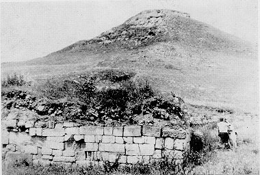
Up to now the finds from the mountain valleys of Kabardino-Balkaria are scarce and insufficient to confirm the Proto-Bulgarian presence. But there is remarkable centre of the Kuban Bulgars in the upper course of Kuban - the
Humarin gorodishte. It is situated at the high right bank of Kuban near the aul Humara and at 11 km to the north of the town Karakachaevsk. The fortress guarded the approaches to the Kluhor pass, connecting the Kuban valley with Sukhumi at the Black Sea coast
[10]. The gorodishte occupies a narrow and long hill surrounded by deep ravines and is linked with the high plateau by a narrow neck. The enclosed by the walls area was up to 840 m long and 480 m wide, or nearly 250 decares. Kuznecov published several runic inscriptions and symbols from Humarin in 1963
[11] and since 1974 there began systematic archaeological excavations
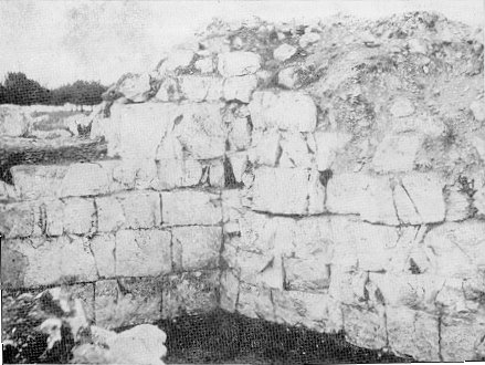
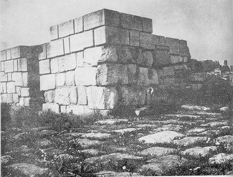
[12]. The excavations revealed a 5-6 m thick fortified wall running at the edge of the hill, built of ashlar blocks with dimensions 0.9 x 0.4 x 0.3 m and 0.5 x 0.35 x 0.2 m, sometimes up to 1.4 x 0.3 x 0.2 m. The blocks were larger near the towers and at the lower part of the walls. These were no foundations - the walls were laid directly on the levelled ground. The facing was always of carefully cut rock blocks, the inner volume of the wall being filled with not so regular blocks. Usually the first row of ashlars was laid breadthwise, the next row - lengthwise, and so on. Clay was the main soldering agent, mortar being used only for the outer lower facing wall. There were 20 equidistant towers along the wall and the high point in the eastern end of the fortress was modelled as a citadel.
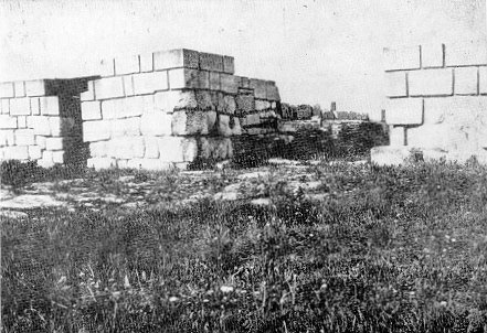
Next to a rectangular tower in the south-western end of the fortress, at the foot of the citadel there was unearthed a small, but intriguing building, built later than the fortress. It represents a rectangular single chamber, 7 m long and 6.2 m wide. Its 0.75-1.0 m thick walls consist of very elaborately cut ashlar blocks. In the centre of the room there was a levelled square platform (2.5 x 2.4 m), shouldered by a double line of ashlar blocks. The clayey platform bears the signs of fire and the whole building is oriented towards the summer sunrise. All points it had religious functions, it can be compared with the Zoroastrian shrines in which the altar with a burning fire occupied the central place. The described previously pagan beliefs of the population of the town of Varachan, the capital of the 'Kingdom of the Huns' illustrated the religious syncretism between the principal Turkic deity Tengri-Tangrikhan and the Iranian god of the sun Kuara. We may suppose that the worshipers of Tangrikhan had adopted the plan of the religious building as well as some elements of the fire cult of the Zoroastrians. It is confirmed by a number of archaeological finds from the political and religious centres of Danube Bulgaria. In its first capital Pliska, the residence of the Bulgarian rulers, there is a similar building - two entered one into another squares of ashlars
[13]. A second, much larger building, oriented towards the sunrise, was excavated near the Throne palace in Pliska. Its religious utilization is confirmed by the fact that after the adoption of Christianity the building was transformed into a Christian church (the so called Palace church)
[14] Similar buildings are also found in Preslav
[15]. Similar in plan is the pagan sanctuary at the Proto-Bulgarian religious complex of Madara, near the location Daul tash
[16].

Scheme of the sanctuary of Humarin. A feature of the Humarin gorodishte are the many runic symbols, letters and words found on the walls and other buildings. They have been written not only after but also during the process of construction of the fortress - graffiti were found embedded into the wall ashlar blocks
[17], some symbols were found even under the mortar coat. Most frequent are bipods and tridents, swastikas, the letter X and H as well as the very characteristic for the Proto-Bulgarian finds along the Danube letter Y.
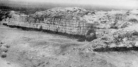
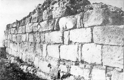
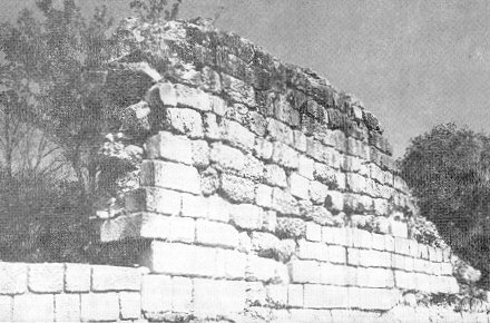
 The Humarin gorodishte. The tower next to the gate with ashlar blocks. At the far end - the citadel of the fortress.
Even the first investigator Kuznecov pointed out that the finds of Humarin are close to those of the Saltovo-Majack culture, which belong to the Proto-Bulgarians. The pottery does not differ from the Saltovo-Majack examples from the Azov lands. The numerous runic letters and even words, as well as the specific graffiti also point to the Proto-Bulgarians. The Humarin gorodishte was dated by its pottery to the VIII-X c.
[18]. The insufficient excavations and the absence of a studied necropolis do not allow to determine exactly to which Proto-Bulgarian group Humarin belonged, but the traces of an earlier Alanian settlement (IV-VII cc.) beneath the fortress show that this Proto-Bulgarian group reached the upper course of Kuban after the Khazar expansion of the VII c. and as a result of that expansion.
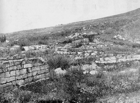
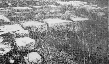
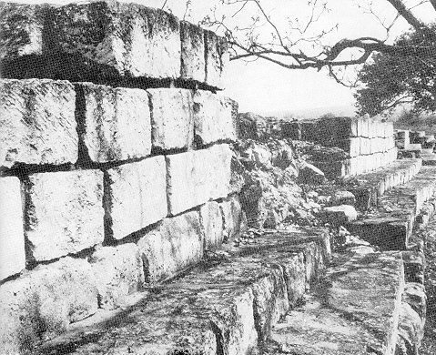
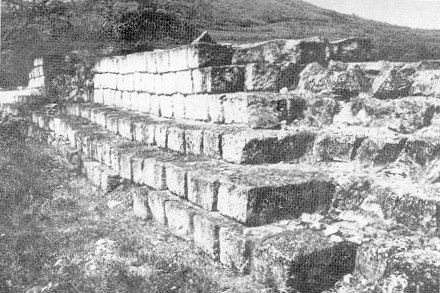
 Part of the fortified wall of Humarin and the pagan sanctuary next to it.
The Humarin gorodishte is a very important example of the Proto-Bulgarian culture. It represents the earliest occurrence of the monumental Proto-Bulgarian constructions of the quadra type technique. That technique differs sharply from the coeval and the earlier local, mainly Alanian, fortresses of the central Fore-Caucasus. The building technique was apparently borrowed from the countries to the south of the Caucasus and from the Near East, where the quadra technique was quite common. Similar to Humarin is also the fortress of Derbend, where some Proto-Bulgarian presence, even if episodical, is attested by the pottery and the characteristic graffiti of horses and riders. Indeed, there are differences between Derbend and Humarin - the quadras of Derbend are much more uniform in size and form perfectly horizontal rows, tied by mortar and with good foundations. In Humarin the size of the quadras varies, the rows are uneven, mortar is rarely used. The constructors could not even lay foundations, they had just levelled the ground without even removing the soft soil layer. That made them build the walls very thick - 5-6 m. The barbarian way of building points that the construction was a work of former nomads with no previous experience. Only the Proto-Bulgarians could be these nomads.
As early as at the end of the last century F. Miller advanced the hypothesis that the name of one of the Turkic peoples of the region - the Balkarians, has preserved the ethnicon of the ancient Bulgars
[19]. His argumentation was accepted almost unanimously by the scholars, who admitted the Proto-Bulgarian contribution to the ethnogenesis of the Balkarians
[20] and the akin to them Karachais, inhabiting the upper course of Kuban
[21], where Humarin is situated. The archaeological and documentary data unambiguously confirm the presence of Kuban Bulgars in the valley of Kuban and in Balkaria, where they mixed with and assimilated the remains of the earlier Alanian population
[22] There are, however, disagreements between the scholars who give prominence to the Proto-Bulgarian contribution
[23] and those scholars, who think that the later Cumans (Kipchaks) have played the predominant role in the ethnic make up of the Balkarians and the Karachais and their language
[24].
References: [1] S.A. Pletjnova. Drevnie bolgarii, s. 13, 15.
[2] S.A. Pletnjova. Srednevekovaja keramika Tamanskogo gorodishta, s. 5, 66-68.
[3] K.P. Patkanov. Iz novogo spiska ..., s. 29.
[4] V.A. Kuznecov. Glinjaniie kotlii Severnogo Kavkaza. - Kratkie soobshtenijaInstituta arheologii AN SSSR, 99, 1964, s. 34, 38-39.
[5] Ja. A. Fjodorov, G.S. Fjodorov. Rannie tjurki na Severnom Kavkaze, s. 71-73.
[6] V.B. Kovalevskaja. Arheologcheskie sledii prebiivanija drevnih bolgar..., s. 50.
[7] L. Bobcheva. Glineni kotli ot rannosrednovekovnoto selishte pri s. Topola, Tolbuhinski okryg. - Izvestija na Narodnija muzej - Varna, XVI (XXXI), 1980, s. 126-130.
[8] V.A. Kuznecov. Alanskie plemena Severnogo Kavkaza, s. 80-81.
[9] E.I. Krupnov. Otchet o rabote arheologicheskoj ekspedicii 1947 g. v Kabardinskoj ASSR. - Uchen. zap. Kabardinskogo NII, IV, Nal'chik, 1948, s. 317-318.
[10] H.H. Bidzjiev, A.V. Gadlo. Raskopki Humarinskogo gorodishta v 1947 godu. - V: Arheologija i etnografija Karachaevo-Cherkessii, Cherkesk, 1979, s. 27.
[11] V.A. Kuznecov. Nadpisi Humarnskogo gorodishta. - Sovetskaja Arheologija, 1963, No 1, s. 298-305.
[12] N.H. Tatorkulov. Raskopki gorodishta Humara. - Arheologicheskie otkriitija 1977 g., M., 1978, s. 107-108.
[13] Peter Karasimeonov. Neue Ausgrabungen in der Residenz von Pliska. - Izvestija na Bylgarskija arheologicheski institut, XIV, 1940-1942, S. 162, Abb. 229, 236.
[14] St. Mihajlov. Dvorcovata cyrkva v Pliska. - Izvestija na Arheologicheskija institut, XX, s. 229-264.
[15] J. Gospodinov. Razkopki v okolnostta na Preslav. - Izvestija na Varnenskoto arheologichesko druzhestvo, VI, 1916-1918, s. 158-159;
N. Mavrodinov. Prouchvane na cyrkvata vyv "Vynkashnija grad" na Preslav. - Godishnik na Narodnija muzej - Sofija, V, 1933, s. 223-228.
[16] D. Ovcharov. Prabylgarskite kapishta - proizhod i prednaznachenie. - Vekove, XII, 1983, kn. 2, s. 56-62.
[17] H.H. Bidzhiev, A.V. Gadlo. Opt. cit., s. 46.
[18] H.H. Bidzhiev. Humarinskoe gorodishte (VIII-X vv.). - V: Sbronik v pamet na St. Vaklinov, S., 1984, s. 122-123.
[19] V.F. Miller. Osetinskie etjydii, t. III, M., 1887, s. 60.
[20] The modern Balkarians inhabit several mountain valleys in the central Fore-Caucasus, at the territory of Kabardnino-Balkarian ASSR. They number around 50,000 people.
[21] Karachais inhabit the upper cource of Kuban, the hightermost part of Caucasus next to Elbrus. According to the cencus of 1970, they number 112,711 people.
[22] E.P. Alekseeva. Nekotoriie zamechanija po voprosu proishozhdenija balkarcev i karachaevcev, s. 103-106. - V: Sb. materialii nauchnoj sessii po probleme proishozhdenija balkarskogo i karachaevskogo narodov (22-26 ijunja 1959 g.). Nal'chik, 1960.
[23] A.H. Sottaev. Proishozhdenie balkarcev i karachaevcev po danniim jaziika, s. 83, 94 - V: Cb. materialii nauchnoj sessii po probleme ..., Nal'chik, 1960.
[24] L.I. Lavrov. O nekotoriih etnograficheskih danniih po voprosu proishovdenija balkarcev i karachaevcev. s. 66-67;
T.H. Kumiikov. Etnogenezis balkarskogo i karachaevskogo narodov v istoricheskoj literature, s. 22-24. - V: Sb. Materialii nauchmoj sessii po probleme ..., Nal'chik, 1960.
The Proto-Bulgarians north of the Black Sea and the Sea of Azov in the VIII-IX cc.
The continuous excavations in the lands to the north of the Black Sea and the Sea of Azov reveal that during the VIII-IX cc. they were inhabited by numerous population, who had created the so called Saltovo-Majack culture. Its bearers had been mainly Proto-Bulgarians and Alans
[1]. Particularly important is the fact that while the nomadic Proto-Bulgarians had left virtually no traces prior to the VIII c., in the middle of the VIII c. there appeared many permanent settlements and fortified sites
[2]. The appearance and development of the Saltovo-Majack culture were stimulated by the settlement down of the Alans and the Proto-Bulgarians and by the internal stabilization of the Khazar Khaganate. The highest concentration of Saltovo-Majack finds occurs in the lands along the rivers Don and Severski Doneck, and they show many similarities with the culture of Danube Bulgaria.
It is generally assumed that the Alans of the upper courses of Don and Severski Doneck were immigrants from the Fore-Caucasus, which they were forced to leave after the Arabian expansion. Immediately after reaching their new lands they settled down. This is an evidence that they were sedentary people even before the migration. It seems that some Alans-nomads, who before that lived the same nomadic life as the Proto-Bulgarians of the north Black Sea steppes, also settled down. This increased significantly the number of settled Alans.
More complicated is the question about the origin of the Proto-Bulgarians, who occupied the lands to the south of the forest-steppe belt, along the lower Don and the middle and the lower courses of Severski Doneck. Up to now there are no reliable data about any Proto-Bulgarian migration from that region caused by the Khazarian expansion other than the "movement" of a part of the Kotrags. More seriously was affected the population of the steppe belt along the left bank of lower and middle Dnepr, as evidenced by the "Pereschepino" type finds. Recently some scholars proposed that the Proto-Bulgarian population of lower Don and middle Doneck appeared there only in mid-VIII c., after the Khazaro-Arabian wars. According to them great masses of Proto-Bulgarians left the Caspian steppes and the foothills of Fore-Caucasus and migrated in north-west direction
[3]. There is no doubt that the Arab campaigns cause significant displacements among the north Caucasian peoples. We mentioned the Alans already. It is quite possible that the wide steppes north of the Azov and of Crimea had accommodated some immigrants from the eastern Fore-Caucasus, but their numbers could not be great and they were quickly assimilated by the older Proto-Bulgarian populations there. Evenmore, it is assumed that the central Fore-Caucasus was occupied by immigrants from the eastern Fore-Caucasus. This would reduce further the possible influx of Proto-Bulgarians to lands along Don and Doneck. It is indicative, that necropolises of northern orientation, which are characteristic to the east of Don and for Northern Dagestan, do not appear in the lands west of Don. But they are found on the left bank of Don - in Artjuganovo, Sarkel and Semikarakorskoe gorodishte. These necropolises might belong to immigrants from Northern Dagestan, as evident by the vine-growing developed near the right-bank Cimljanskoe gorodishte.
The investigations of Pletnjova, complemented by several later works allow the reconstruction of the process by which the former nomads-Proto-Bulgarians were transformed into settled farmers, craftsmen and builder, who had created several impressive monuments.
It was already mentioned earlier that the earliest Proto-Bulgarians archaeological finds from lower Don are the extensive collective nomadic camps (kureni). Fragments of Crimean and Byzantine amphorae, found there are dated from the VII and even VI c. Similar is the picture from the middle course of Severski Doneck. Remains of extensive temporary nomadic camps are found in the upper courses of its small tributaries. The finds are very scarce - mainly hand-made pottery and imported amphorae, which points out that these camps had been visited only episodically
[4]. Almost simultaneously another type of temporary camps appeared - camps which were situated in the protected against the cold steppe winds valleys of the rivers. Here the finds are 2-3 times more numerous and the share of wheel-made pottery is increased. Most probably the latter camps served as a winter shelters for the nomads.
During the next phase of reclaiming the land the stock-breeders founded small permanent settlements along the middle and upper courses of the small tributaries. First there appeared small temporary settlements, which were located at non-inundated terraces near the river banks. They already had clear cultural horizons, up to 0.3-0.5 m thick, and they were inhabited for much longer. The excavations at Podgaevka and Novokilimarevka show that these temporary settlements consisted of 8-10 houses, built in semicircle and forming an inner yard. The wheel-made pottery predominates. Such small camps (auli) belonged to less numerous semi-nomadic groups, created after the disintegration of the tribal structures (kureni).
The temporary settlements, which were suitable for settled life, developed into permanent ones. The latter were fundamentally different both in topography and in structure. While the temporary ones occupied the upper valleys' bottoms with abundant grazing grounds around them, the permanent settlements were situated as a rule on the high right banks of the middle and lower courses of the rivers, suitable for agriculture. In contrast to the temporary ones, they have distinctive cultural layers containing numerous artefacts. The pottery is almost exclusively wheel-made, there are also found millstones, sickles, scythes, axes, ploughshares, etc. The light transportable jurts were replaces by circular or close to circular dwellings, some of them dug in 0.4-0.5 m up to 1.0-1.5 m into the ground, thus transformed into semi-dug-outs.
The settling down of the Bulgaro-Alanian population in mid-VIII c. led also to the appearance of fortified strong-holds. The earliest ones were situated on naturally protected promontories along the river-banks, they were surrounded by earthen ramparts and encompassed relatively large areas - 40-70 decares. They were permanently occupied.
Another type fortified settlement were protected by stone walls (up to 5 metres thick), but the area encompassed was much smaller. They also occupied promontories. Often (in 5 out of 12 gorodishta) the inner most inaccessible part - the citadel, was additionally protected by another stone wall. Two of the these gorodishta - the Majackoe and the Right-bank Cimljanskoe are very important for the study of the Saltovo-Majack and the Old Bulgarian culture.
The
Right-bank Cimljanskoe gorodishte (see
Map) is some 250 km to the north-east of the mouth of Don. The fortress occupies a triangular promontory with steep slopes and connected by a very narrow isthmus to the main plateau.
 Scheme of the Right-bank Simljanskoe gorodishte (accorfding to Pletnjova).
The 4 m thick stone wall consist of an inner and outer facings, built of regular white ashlar blocks (dimensions 0.6 x 0.3 x 0.3 m), the space in between was filled with smaller stones and pebble. One row of ashlars was laid breadthwise, the next row - lengthwise, etc. The high of the walls was 4 metres, and there were 5 towers - two of them guarding the isthmus and other two - above the river Don. The inner space was inhabited, but no massive building are found. The dwellings were light jurts or semi-dug-outs. One jurts however stands out with its dimensions - 6.5x5 m. It has three rooms, interpreted by Pletnjova as a male and female part and a linking central room, and most probably it belonged to the local feudal, the ruler of the fortress.
A suitable building material is not found locally, the nearest quarries which could provide the necessary building material are some 100 km higher along Don. The white fortresses high on the steep hill must have been an impressive sight.
The exavations yielded abundant iron agricultural tools - sickles of different types, light and heavy ploughshares, scythes, etc. Very interesting are and iron vine sickles. This find in a fortress which is in the centre of one of the most important vine-growing regions in Southern Russia speaks about the early origin of the vine-growing in this region.
The inhabitants abandoned the fortress fleeing from some enemy. They buried some of their possession never to return afterwards. Today the excavations unearth these hidden 'treasures', the agricultural, fisherman's and other tools characterize the occupation of the inhabitants. Many are items of parts of the military equipment - iron arrow-heads and spare heads, reins stirrups, etc. One 'treasure' consists of part of the blacksmith's (an anvil, pliers, chisels, files), the carpenter's (axes, saws, various chisels) and goldsmith's (a smaller anvil, nippers, small hammers) equipment. The pottery is representative for the Saltovo-Majack culture, characteristic are the numerous cauldrons with inner lugs.
The fortress was built during the final quarter of the VIII-th c. Notwithstanding its defences and protected environment, it was taken by assault and destroyed by an enemy, who did not spare the population, mostly women and children. Beneath the fire-burned walls of the dwellings at many places were discovered skeletons. The end of the Right-bank Cimljanskoe gorodishte is dated by the find of some 50 Sassanid and Arab coins from the first quarter of the IX-th c. Research showed that the other settlements the vicinity, although far less protected, were not destroyed which excludes an external enemy. Pletnjova proposed that the right-bank Cimpljanskoe gorodishte was destroyed by the ruler of the neighbouring Khazar fortress of Sarkel, who would not accept an independent Proto-Bulgarian ruler in his region
[5] Artamonov, however, does not share her opinion. According to him the first quarter of the IX-th c. evidenced the adoption of Judaism by the Khazars, which led to prolonged internecine wars. The Cimljan ruler obviously took the side of the Khazar enemies and was punished accordingly. After the destruction of the right-bank Cimljanskoe gorodishte the Khazars built another fortress - Sarkel, which became their stronghold in the region.
One part of the population returned to Cimljan after the debacle, however the fortress lost its military importance and was transformed into a casual village of fishermen. It was taken and destroyed again by the Pechenegs in the end of the IX-th or in the beginning of the X-th c.
The other ruins of particular interest, the
Majackoe gorodishte (see
Map) is situated at the northern edge of the steppe, near the lesso-steppe belt and it is the northernmost example of the Saltovo-Majack culture.
 Scheme of the Majackoe gorodishte.
The ruins occupy a 80 m high hill - promontory on the lower inundated terrace of the river Tikhaja sosna, at its confluence with Don. The relative accessibility of the place required great volume of additional work on the fortifications - the neck of the promontory was cut off by a ditch 6 m deep and 12-13 m. wide. The rectangular fortress (100 m by 85 m) was built of regular ashlar blocks with dimensions 0.6 x 0.3 x 0.3 m,
the same as in the Right-bank Cimljanskoe gorodishte). As in the other two cases the walls had no foundations, they were laid directly on the levelled ground. The blocks formed two walls, the inner space being filled with not so regular blocks and pebble. The total thickness of the walls was 6 m, somewhere up to 7 m, and the height - 6.0-6.5 m. The entrance was of the NW wall, guarded by a massive rectangular tower. An inner 42 m x 27 m rectangular fortification, contiguous to the SW wall, served as a residence for the local ruler.
 Part of the built of quadras wall of the Majackoe gorodishte.
 Majackoe gorodishte. Part of the inner side of the wall with the typical ashlar blocks.
To the east of the ruins there is a large catacomb necropolis. The characteristics of the burials (few artefacts, the predominance of single burials, some differences in the structure of the dromos, etc.) link them with the Proto-Bulgarian pit burials and, especially, with the Chirjurt catacombs. Another peculiarity are the numerous signs and graffiti chiselled or scratched on the limestone quadras of the fortification. Besides the drawings of horses, donkeys, deer and other animals; scenes of a fight between a horseman and a footman, etc.) there are many symbolic signs - swastikas, pentagrams, crosses, etc. as well as runic inscriptions. The drawings, the signs and the runic inscriptions are absolutely similar to those from Bulgaria and from the treasure from Nagy Saint Miklos. All this evidence made Pletnjova to attribute the Majack gorodishte to the typical Proto-Bulgarian monuments. Plausible also looks her hypothesis that Majack was built by immigrants from Cimljanskoe, who took refuge in these northern lands among the friendly Alans after their own town was destroyed by the Khazars.
Proto-Bulgarian presence was also attested in Sarkel, the principal Khazar stronghold in the area. Sarkel,
now under the waters of the Cimljanskij reservoir, was built some 15 km to the east of the Right-bank Cimljanskoe gorodishte. The excavations
[6] revealed that the Proto-Bulgarians were the main inhabitants of Sarkel during the Khazar period - the drawings, signs and the runes in Majack and Sarkel are very close, they also have counterparts on the quadras and bricks from the first Bulgarian capital of Pliska. As in Danube Bulgaria many if the signs were scratched on the walls and handles of the pottery, especially amphorae. The very name of Sarkel ("White house, White fortress") does not fit to its red wall, built of bricks. Artamonov is very convincing in saying that Sarkel, built after the destruction of the white fortress (Righ-bank Cimljanskoe, which was probably called 'White town, White fortress') on the other bank of the river, took the name of the opponent.
The numerous runes and symbolic signs on the bricks of Sarkel are very important having in mind the scarcity of such material in Right-bank Cimljanskoe. The latter was virtually destroyed in 1744, when its quadras were re-used by the military.
---------
Immigrants from Dagestan had obviously influenced the pottery production in the Lower Don region - the structure of the local pottery kilns is identical to that from Andrejaluskoe gorodishte. However, it was the traditions of the Alans who had the greatest influenced over the development of the Proto-Bulgarian pottery.
The two built of white quadras fortresses along Don are distinctively different from the stone fortifications of the Alans as well as from the Khazar centre of Sarkel. They are unequivocally related to the Humarin ruins on Kuban and a number of fortifications in Danube Bulgaria.
It was mentioned already that the Proto-Bulgarians believed that under certain conditions a man could be possessed by an evil spirit. Consecutively, there was number of "safeguarding measures" (as evident in the burial rites). In similar terms was also explained the unnatural behaviour of mentally ill people and epileptics. In order to "drive away" the evil spirit, besides the ordinary repertoire of incantations and religious-magical procedures, there were another, more radical measures, performed by a specialized category of medicine-men. They performed trepanations of the scull, usually near the saggital suture. A significant number of such trepanations, sometimes several on one scull, is attested among the Proto-Bulgarians of this group and especially among the Volga Bulgars
[7] But the Proto-Bulgarians from Severskij Doneck went further - in the necropolis of Zholtoe, near Voroshilovgrad, were discovered two sculls with not symbolic, but medical trepanation: the sculls were bored by a silver plate, in one case the patient had a haemorrhage of the brain and in the other - a brain tumour
[8].
References: [1] I.I. Ljapushkin. Pamjatniki saltovo-majackoj kul'turii v bassejne r. Dona, s. 85-150.
[2] S.A. Pletnjova. Drevnite bylgari v Iztochna Evropa, s. 33
[3] S.A. Pletnjova. Drevnite bylgari ..., s. 12, 16.
[4] S.A. Krasil'nikov. Vozniknovenie osedlosti u prabolgar Srednedonech'ja. - Sovetskaja Arheologija, 1981, No 4, s. 110-111.
[5] S.A. Pletnjova, Ot kochevij k gorodam ..., s. 39. The Proto-Bulgarian character of the inhabitants of the fortress is confirmed by the anthopological material from the burned dwellings - it belonged to brachyochranic europeids with slight Mongoloid features - the characterstic features of the Zlivka Proto-Buglarians.
[6] M.I. Artamonov, Istorija khazar, s. 313-316; V.V. Ginsburg. Antropologicheskij sostav naselenija Sarkela - Beloj vezhi i ego proizhozhdenie. MIA, 109, 1963, s. 260 sl.
[7] P. Boev. Simvolichni trepanacii ot SSSR. - IIM, XI, 1965, s. 133 sl.
[8] K.I. Krasil'nikov, A.A. Ruzhenko. Pogrebenie hirurga na drevne bolgarskom mogil'nike u s. Zheltoe. - SA, 1981, No 2, s. 284-288; G. markov, D.Il. Dimitrov. Simvolichni i lechebni trepanacii u prabylgarite. - Jubilejna nauchna sessija na VMI - Varna (XI.1981 g.). Varna, 1982, s. 199-202.
The Proto-Bulgarians in the Crimea in the VIII-IX cc.
The Crimea and the peninsula of Kerch were also affected by the migrations of the first half and the middle of the first millennium - the destruction, accompanying the Gothic and, especially, the Hunic invasions left to the abandonment of the smaller towns and almost all unfortified villages. Among the big towns only Chersones survived relatively intact and preserved its previous position. The town of Panticapeus, the capital of the local Kingdom of Bosporus, also survived and was renamed into Bosporus - the present Kerch. Its population and size decreased significantly, and its culture was barbarized
[1]. Similar to the other survived coastal settlements, Bosporus began to supply the steppe inhabitants with artisan's goods - pottery, decorations and other luxury goods.
In the VI-th c. new steppe people started to settle down in some of the declined villages or the ruins of the abandoned towns. But this process was very slow till the mid-VII-th c. After the disintegration of Great Bulgaria and especially towards the end of the VII-th c. there was a new massive influx of nomads towards the flat country of the Crimea. The process was further intensified in the VIII-th c., when the new settlers occupied not only the plains but penetrated into the central part of Taurida and reached the NW coast of the peninsula
[2]. Thus for a relatively short period of time the ethnic character of the area was significantly altered and a new culture appeared. The archaeological investigations in the last decades discovered more than 100 villages and 10 necropolises and threw new light on the ethno-cultural processes in the area
[3].
Most of the settlements were unfortified which is easily explained by the political stability existing in South-Eastern Europe after the consolidation of the Khazar power. The villages were situated mainly near water, in the river valleys or on the sea coast. The inhabitants obviously were looking for the most favourite conditions for agriculture and stock-breeding. Another feature is the the new builders did not take into account the previously existing buildings. Usually new grounds were used, but even in case of overlapping, the new buildings were dug in within the older ones. The settlements were large - 200-250 decares on average and up to 1600 decares (Tau-Kipchak), but it did not mean they were populous - they consisted of several clusters of buildings some 50-200 metres apart. The researcher (Baranov) pointed out that this planning is similar to that of a number of mountainous villages in Caucasus and corresponds to the patriarchal family structure, where the head of the family occupies the central building with the other members taking the lesser buildings next ot it.
The traditional structure of the semi-dug-outs, however, could not be preserved in the climate of Crimea - the underground parts of the dwellings had to be strengthened by a stone wall. Another stone wall was erected above the ground. The builders, former nomads, without the necessary experience in masonry, could not joint the walls and rounded the corners instead. The dug-outs also became shallower - up to 0.3-0.4 m, and later the whole buildings were erected above the ground.
 Schemes of the rectangular semi-dug-outs with rounded corners and stone wall from the Proto-Bulgarian settlements at Tau-Kipchak (1) and Geroevka (2) in the Crimea.
Under the influence of the local Crimean traditions the whole buildings started to be built of stones. But the unifying feature of all buildings of the "Saltovo-culture" Proto-Bulgarians in Crimea is the 'pine-tree' (imbrication) building technique. The researchers are unanimous that it spread in the Crimea and the neighbouring Taman peninsula only after the coming of the Proto-Bulgarians
[4]. Pletnjova thinks that the 'pine-tree' technique was brought in here from the Caucasus, where it was well known in the VI-IX-th centuries. Her supposition is quite plausible, having in mind that the migration of a significant part of the population of the Northern Dagestan as a result of the Khazaro-Arab wars. It is also indicative that the 'pine-tree' technique appeared almost simultaneously in Taman and in the Crimea, which was also accompanied by a sharp increase in the number of the "Saltovo-culture" Proto-Bulgarian villages - 82 out of total number of 109 discovered Proto-Bulgarian settlements belong to the period between the second half of the VIII-th and the IX-th c.
The settlements of the later period in contrast to the previous period more often appear above the ruins of the previous towns. This increased the possibilities of contacts between the newcomers and the older population, which had preserved the traditions of the antiquity. The cultural influence of the latter increased further when a sizeable group of Greek population from Asia Minor was resettled in southern, coastal Crimea in the second half of the VIII-th c. The semi-dug-outs were replaced by dwellings (sometimes above the ground), consisting of one or two rooms. Such two-chamber dwellings from the IX-th c. are discovered in all more or less important agricultural settlements in the Crimea and Taman - Ilurat, Bakla, Alekseevka, Planerskoe, Phanagoria, etc.
There were, however, differences between the Byzantine and the Saltovo two-chamber buildings. The Byzantine ones consisted of two rooms, with a door between them and fireplaces in each of the rooms, which indicated that both rooms were inhabited. The roof was covered with tiles. The Saltovo examples only one of the rooms had fireplace and the two rooms were not connected. Therefore, only one of the rooms was inhabitable while the other one served economic purposes. The floor was dug in a little bit and the walls were constructed of clay laid on a wooden framework, with stone foundation built in the 'pine-tree' style and a straw roof. The differences with the Byzantine buildings are also displayed in the two Proto-Bulgarian churches in Planerskoe and in Kordon-Oba. The church in Planerskoe is built of bricks arranged in the 'pine-tree' style
[5]. The church in Kordon-Oba displays the same construction and the inability to joint the walls at the corners. These two churches illustrate the increased Byzantine influence and the adoption of Christianity by part of the population but also their conservatism.
The conservatism in the material culture is also displayed in the pottery, which preserved the main characteristics of the steppe variant of the Saltovo-Majack culture. An interesting development is observed in the manufacturing of roof tiles. First, in the VIII-IX-th cc. it was concentrated in the towns where the buildings were constructed in the 'pine-tree' style. Later - in the IX-X-th cc. its centre moved to the Byzantine-held Chersones. The tiles bear various embossed signs, up to 1 cm high. Most of the signs are Greek letters or combinations of letters and obviously indicated the work of certain masters or production centres. In the smaller and the older centres the signs, however, resemble runic letters, animal figures or symbols of trees, crosses, pentacles
[6] and are never found in Chersones. Jakobson pointed out that these relief signs are characteristic only for the lands to the north of the Black sea and especially for the Crimea. They are not found during this period of time (VIII-X cc.) in Byzantium. In the earlier centuries (VI-VII cc.) these signs were not found in the Crimea either. According to him it is not a coincidence that the tradition of embossing such signs spread in the VIII-th and IX-th centuries, and exactly in those villages where life was resumed after the influx of the new population with noticeable signs of nomadic culture. The drawings and signs on quadras from Crimes also much resemble those from the Proto-Bulgarian artefacts from Don and Kuban. All this points that the practice of putting signs of the roof tiles in Taurida was brought by the Proto-Bulgarians who settled there in the VIII-th c.
The necropolises, although still poorly studied, show that the pit burials in Crimea are closely related to the typical Proto-Bulgarian burials of the 'Zlivka' type. Europeid brachyocranic types, rarely with Mongoloid features, predominate
[7]. This anthropological type is not found in Chersones, although it is characteristic for the cave monasteries of the Crimea
[8]. All collected data make the researchers conclude that in the VIII-IX-th centuries the Proto-Bulgarians, frequently mixed with the remains of the local population, were the main inhabitants not only of Eastern, but (apart from several larger towns) also of the Southern and SW Crimea
[9].
At the end of the IX-th c. or in the beginning of the X-th century almost all Proto-Bulgarian settlements were destroyed and abandoned by their inhabitants
[10]. The most plausible explanation is that it was caused by the invasion of the Pechenegs, who destroyed almost all Saltovo-Majck type settlements
[11]. The Pecheneg invasion also affected the cave monasteries, built in the mid-VIII-th c. by immigrants from Asia Minor. The affected population had to flee, some of them found refuge in the coastal towns, while others had to leave the Crimea and to look for safer places farther in the west, where they spread many characteristics of the Crimean culture.
References: 1. V.F. Gajdukevich. Bosporkoe carstvo. M., 1949, s. 479
2. I.A. Baranov. Nekotoriie itogi izuchenija tjurko-bolgarskih selisht Tavriki. - V: antichnaja drevnost' i srednie veka, viip. 10. Sverdlovski, 1973, s. 131-132.
3. I.A. Baranov, Op. cit., s. 57
4. A.L. Jakobson. Rannesrednovekoviie sel'skie poselenija Jugo-Zapadnoj Tavriki. - MIA, 168, 1970, s. 118-199.
5. V.P. Babenchikov. Itogi issledovanija srednevekovogo poselenija na holme Tepsen'. - V: Istoija i arheologija srednevekovogo Kriima, M., 1958, s 147.
6. A.L. Jakobson, Op. cit., s. 156
7. Ju.D. Benevolenskaja. Antropologicheskie materialii iz srednevekoviih mogil'nikov Jugo-Zapadnogo Kriima. - MIA, 168, s. 196 sl.
8. G.F. Debec. Antropologicheskij sostav naselenija srednevekoviih gorodov Kriima. - MAE, XII, 1949, s. 346, 386.
9. A.L. Jakobson. Kul'tura i etnosrannesrednovekoviih selisht Tavriki. - V: Antichnaja drevnost' i srednie veka, viip. 10. Sverdlovsk, 1973, s. 131-132.
10. A.L. Jakobson. Rannesrednovekoviie poselenija ..., s. 500-501; A.N. Shcheglov. Rannesrednovekoviie poselenija na Tarkhankutskom poluostrove Kriima. - SA, 1970, kn. I, s. 259
11. I.I. Ljapushkin. Pamjatniki saltovo-majackoj kul'turii..., s. 148
The migration of the Unogundur-Bulgars of Asparukh from the lands of Azov to the Lower Danube
The Bulgars of Asparukh occupied the easternmost part of Great Bulgaria, which disintegrated after the death of Asparukh's father khan Kubrat. Asparukh had for eastern neighbours the Khazars and thus his Bulgars were the first to face the Khazar onslaught in mid-VII-th c. Unable to resist, they had to retreat to the west.
The Byzantine chroniclers Theophanes and Nicephorus provide evidence for the settling of Asparukh in the Lower Danubian lands:
'At last the third of them (the brothers), called Asparukh, after crossing Dnepr and Dnestr rivers which are to the north of Danube, and after capturing the Oglos (Onglos), settled in the lands between it and the aforementioned rivers, because he noticed that that place was protected and difficult to attack from any side; being swampy in the front and from the other sides - surrounded by a ring of rivers, it offered great security against enemies for the weakened by the parting people.' [1].
Almost identical is the information of the patriarch Nicephorus
[2]. According to him the place of refuge was called Onglos (Oglos)
[3]. The story of the subsequent battle of Asparukh against the Byzantine emperor Constantine IV provide more info about the location of the Onglos:
'And the emperor Constantine, learning that a ungodly and filthy people settled in the lands beyond the Danube, in the Oglos, and that they attack and devastate the lands near the Danube, i.e. the presently held by them country, previously held by the Christians, was very upset and ordered for the departure of all troops to Thrace. And after arming the fleet, he set against them by land and by sea with the intention to make war with them and to chase them out. The infantry moved in battle lines towards the so called Oglos and the Danube and the fleet was ordered to anchor nearby. The Bulgars, seeing the dense and numerous lines, became desperate, fled in the aforementioned fortification and prepared themselves for defence. In the next 3-4 days nobody of them dared to show up and the Romans did not seek a battle because of the swamps. The filthy people, seeing the Roman weakness, recovered themselves and became bolder. The emperor suffered from a fit of gout and had to return to Messembria to take baths, leaving his generals to start the fighting and to engage them in a battle if they leave their fortifications. Otherwise, to put them under siege and to check their advances. The cavalry, however, spread the rumour that the emperor was deserting them, and fled on their own, without being chased by anybody. The Bulgars, seeing this, attacked and chased them and killed most of them by swords, and many were wounded. And after chasing them up to the Danube, they crossed it.'
Particularly important in the above passage is that the Onglos was a system of fortifications, which the Byzantines could not overcome despite their numerical superiority. This information significantly facilitates the localization of Onglos, which otherwise could be placed anywhere - in the south, in the north from the Danube delta or even in Wallahia.

 Map of the earthen fortifications from the second half of VII-th and the beginning of the VIII-th c.
The archaeological investigation revealed that the earliest type of Proto-Bulgarian defences in the Lower Danube region (the second half of the VII-th c. - VIII-th c.) were the earthen ramparts and ditches. The earliest ones, undoubtedly built before the year of 680 (the year of the Constantine debacle) are the Southern Bessarabian rampart and the Galac fortified camp. The total length of the north-facing Southern Bessarabian rampart is 126 km, its mean width - 31 - 41 m. Its western end is 35 km, and its eastern end - 28 km from the Danube. Immediately next to its western end is situated the fortified camp at Galac, which encompasses the land between the rivers Seret and Prut and is surrounded by water from three sides. The more vulnerable NW side was protected by a rampart and ditch with total length of 27 km, very similar in structure and dimensions (42-43 metres mean width) to the Southern Bessarabian rampart. Two more fortification are situated to the south of Danube: the Little Dobrudzhan rampart and the Nikulicel fortified camp. The Little (Southern) Dobrudzhan rampart covers the narrowest part of Dobrudzha, between the Danube and the town of Konstanca, and it is the oldest of the three earthen ramparts in Dobrudzha. The other two - the Large earthen rampart and the Stone rampart are to the north of it and face the north, while the the Little Dobrudzhan rampart faces the south. The Nikulicel fortified camp in Northern Dobrudzha was protected by an intricate system of earthen ramparts, it encompassed an area of some 48 km2 and could serve as an excellent refuge for a numerous population.
 Scheme of the Dobrudzhan ramparts between Cherna voda and Konstanca.
All these data show that an identical in structure system of defences was built on the both sides of the Danube. Both in the south and in the north there was a fortified camp and it obstructs the equivocal location of the Onglos, used as a refuge by the Bulgars of Asparukh. Most popular is its identification with that part of Southern Bessarabia, which is surrounded by the South Bessarabian rampart. Others identified the Onglos with the Galac fortified camp. K. Shkorpil
[4] proposed that initially, up to the 60-s of the VII-th century, the Bulgars of Asparukh settled in Southern Bessarabia and built the Southern Bessarabian rampart for defence against the Khazars. Later, they occupied Northern Dobrudzha and built the Little Dobrudzhan rampart against the Byzantines. His opinion was further elaborated by R. Rashev
[5] and this is the generally accepted reconstruction at present. According to R. Rashev the Nikulicel fortified camp was the centre of the Asparukh territory, some 15,000 km2.
The archaeological and textual evidence reveal that the led by Asparukh Bulgars, who settled on the both banks of the Danube delta, were a relatively numerous group of nomads, with a robust military organization and significant experience in the military engineering, which allowed them to built an extensive system of defences in a relatively short period of time.
References: 1. Theophanes Op. cit. p. 357-358.
2. Nicephorus. Op. cit., p. 34.
3. That name is found in the two forms: Oglos ( ) and Onglos (
 ). Its etymology is still a matter of debate. Some researchers derive it from the Slavic
  (pronounced "ong'l" = angle, corner). According to them it covered the lands between the rivers Prut, Dnestr and Danube, which were later to be called Budzhak, a Turkish translation of 'corner'. Others think that O(n)glos comes from the Turkic agyl (
 ), meaning "yard, an enclosed place".
4. K. Shkorpil. Starobylgarski pametnici. - V: Dobrudzha. S., 1918, s. 226 sl.
5. R. Rashev. Zemlenata ukrepitelna sistema na Pyrvoto bylgarsko carstvo. - V: Pliska-Preslav, 2, s. 99.
), meaning "yard, an enclosed place".
4. K. Shkorpil. Starobylgarski pametnici. - V: Dobrudzha. S., 1918, s. 226 sl.
5. R. Rashev. Zemlenata ukrepitelna sistema na Pyrvoto bylgarsko carstvo. - V: Pliska-Preslav, 2, s. 99.