.

.
Library of Professor Richard A. Macksey in Baltimore

POSTS BY SUBJECT

Labels

Showing posts with label ANTEDILUVIAN_CIVILISATION. Show all posts

Thursday, October 25, 2012

Comparison between the sign-systems of the Carpathian Basin, the Bosnian Pyramids and Glozel

http://www.rovasirasforrai.hu/Forditasok/Karpat-m_Piramisok_Glozel-ANGOL.htm

Comparison between the sign-systems of the
Carpathian Basin, the Bosnian Pyramids and Glozel


Briefly about the sign-system of the Carpathian Basin

1. The ancient Hungarian runic (rovás) script

The ancient Hungarian runic script developed in the Carpathian Basin. The oldest relics of this revealed until now are signs originating from a 15-20,000 year-old undisturbed layer on a stick in Jankovich cave in Bajót (North Hungary). The symbols on the Tatárlaka (Tartaria) Disc are 7,500-8,200 years old. There are further 6-7,000 year-old relics of this writing, found by Zsófia Torma archeologist (1831-1899) during her excavations near to Tordos, Transylvania. On the territory of the historical Hungary (see the maps made before 1920) several relics of runic writing have remained on stones, church walls, in books, on objects made of bone, wood, silver and gold.
The relics of the runic writing prove the origin of the Hungarian people in the Carpathian Basin (see Klára Friedrich: Tatárlaka titka (Mystery of Tatárlaka) at the website: www.magtudin.org).
The runic script is used even nowadays by the Hungarians; on the territory of the historical Hungary at least one hundred thousand people use it in their daily life. It is now the 10th year since Gábor Szakács journalist, researcher of the runic writing has been organizing competitions for the youth between 9-18 years of age, with an average participation of 700 competitors. So the 15-20,000 year-old symbols are absolutely suitable for use in our days as well, all the more because the sounds of the Hungarian language can be put down perfectly only by this type of writing. Here it is to be mentioned that in the 10th century, when the ancient writing of the Hungarians had to be replaced by Latin letters, 13 sounds of their language (TY, GY, NY, SZ, ZS, CS, LY, J, K, Á, É, Ö, Ü) were missing from the Latin alphabet.

2. Signs on the megalits on Tászok-tető

Tászok-tető can be found in the Carpathian Basin, in Transylvania. Descriptions say that on the 1013 m high plateau and in the surroundings there were several hundreds of written stones, with an average size of 180 x 140 cm. Two unharmed megalits are exhibited in the Tarisznyás Márton Museum in Gyergyószentmiklós, Transylvania and there are some broken stones still laying on the plateau, that's all today. Based upon the parallels it can be stated that the majority of the scripts is about 10,000 years old (see Klára Friedrich: Megalitok a Tászok-tetőn (Megalits on Tászok-tető) in the book: Klára Friedrich-Gábor Szakács: Tászok-tetőtől a bosnyák piramisokig (From Tászok-tető to the Bosnian pyramids) - 2007, available only in Hungarian.
3. Signs of the Tordos-Vinca culture
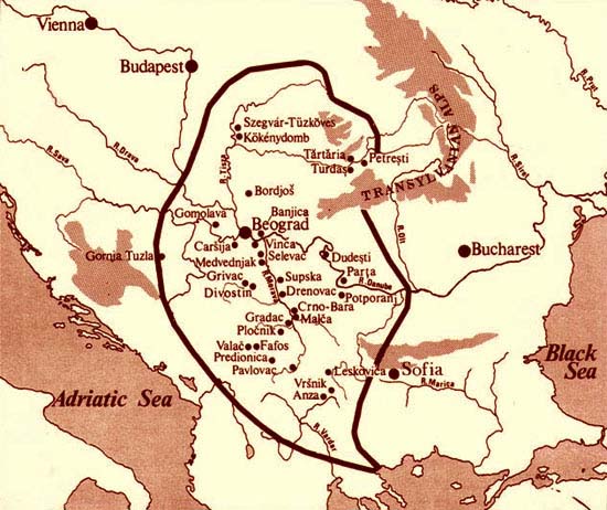
The excavator of the Tordos culture was the above mentioned archeologist, Zsófia Torma. From 1875 she found thousands of clay discs deriving from the neolithic period. Most of the signs on these discs equal to those of the ancient Hungarian runic script being in use even today. In Vinca, a settlement near to Nándorfehérvár (since 1920 Beograd, Serbia) and in the surroundings plenty of artifacts from the neolithic age were revealed from 1905 (see the map of M. Gimbutas).

Sign-systems outside the Carpathian Basin

This paper deals with two of them only, although several other European and Asian sign-systems show similarity with the ancient Hungarian runic script.

1. Signs of the Bosnian pyramids

Semir Osmanagic, a pyramid researcher, began excavations in 2005 in Visoko, Bosnia, 30 km North from Sarajevo. His attention to the pyramidal shape of Visocica Mountain was called by Senad J. Hodovic, curator of the local museum. Besides, it is assumpted that four adjacent hills covered by various plants also hide pyramids. The main sites of the excavations are called as Pyramids of Sun and Moon and the results hitherto achieved have already proved that these are man-made, artificial creations. The Pyramid of Sun is bigger and older than the pyramid in Giza, which was built by order of Pharaoh Cheops 4600 years ago. Gábor Szakács, who went to the site in June 2006 for the first time, found symbols corresponding to the ancient Hungarian runic writing in the tunnel of the Pyramid of Sun and on the great stones laying nearby. Consequently, the territory of the Tordos-Vinca culture has been expanded to the south. In June 2007 I had the opportunity to examine these symbols personally and be convinced of it together with other Hungarian visitors.
Further information about the Bosnian Pyramids is available at the website www.piramidasunca.ba.

2. Glozel

Glozel is a French village where in 1924, in addition to other artifacts, such signs were found on ceramic plates, bones and stones which are very similar to the letters of the ancient Hungarian writing. I drew the attention to this fact in 2003 and 2005, indicating at both occassions the 111 Glozelian signs. (See the book: Klára Friedrich-Gábor Szakács: Kárpát-medencei birtoklevelünk a rovásírás (Runic script is our letter of ownership to the Carpathian Basin) - 2003, p. 81 - available only in Hungarian and the book: Klára Friedrich-Gábor Szakács: Kőbe vésték, fába rótták (Carved into stone, engraved into wood) - 2005, the chapter entitled "Tatárlaka titka" on pages 48-83 (Mystery of Tatárlaka - in English available at www.magtudin.org).
According to the official standpoint the age of the Glozelian signs is 1,800-2,300 years. See: www.glozel.net

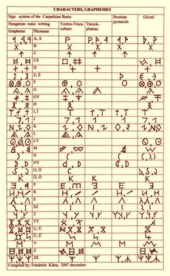
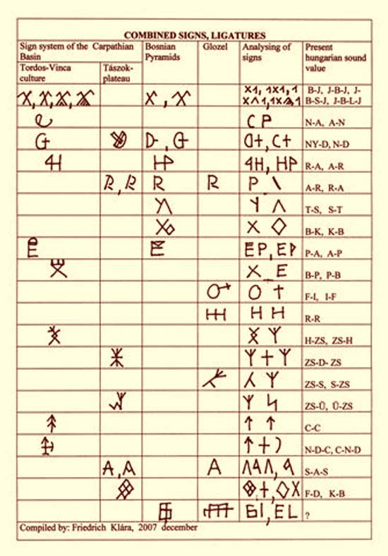
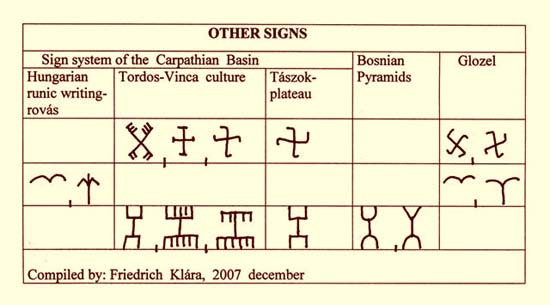
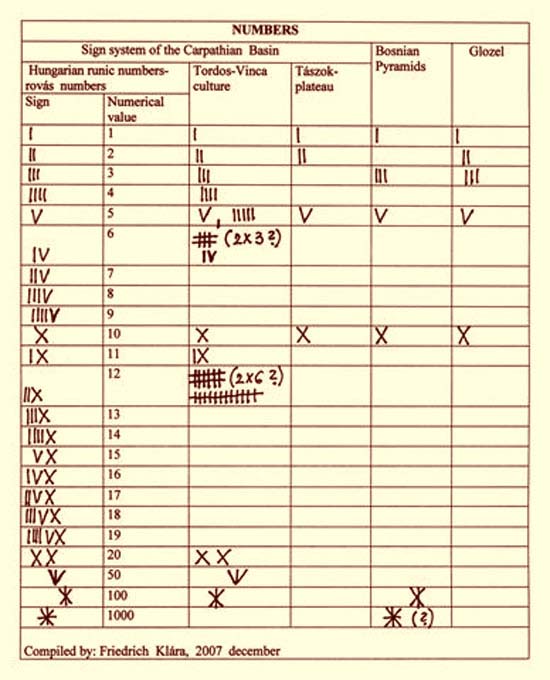
Comparative tables of the signs

Having reviewed the tables we are entitled to presume that in the Carpathian Basin, on the territory of the Bosnian pyramids and in Glozel representatives of the same culture were acting and left their written signs to us. A remarkable aspect is that on the territory of the historical Hungary (before 1920) these signs are in use even nowadays.

Literatur:Gimbutas, Marija: The gods and goddessess of old Europe (Berkeley,1974)
Szakács Gábor: Tudósítások a bosnyák piramisokról (Magyar Demokrata, 2006/26, 45, 48)
Tomory Zsuzsa: Kezdeteink (Miskolci Bölcsész Egyesület, 1995)
Torma Zsófia: Sumer nyomok Erdélyben (Buenos Aires, 1972)
Winn, Shan, M.M: Pre writing in south-eastern Europe (Western Publishers, 1981)
----------
Budapest, in December 2007
Klára Friedrich
Researcher and Teacher of Hungarian Runic (rovás) Writing

Sunday, October 21, 2012

Mississippi Tsunami and Caribbean Megafloods


Mississippi Tsunami and Caribbean Megafloods

While doing research on Ice Age art in North America I came upon something quite different that was worth going into here. Quoting from a site which displays some highly controversial works that the authors are supporting as Ice-age art (Which we need not go into at present):

A more recent theory propose prehistoric Solutreans of Ice Age France also sailed west to America across the Atlantic Ocean along the south ridge of the polar ice cap more than 18,000 years ago. It is thought they brought Clovis point technology (earlier, similar points were found in France) and genetic diversity (such as red hair and large noses) to Native Americans.[2]
....
What Happened to the Mega Fauna and the Paleo-Indian? Then suddenly everything changed. A geological black-layer deposit of carbon containing nano-diamonds at over 50 locations in North America tells the tale: About 12,900 years ago a huge Ice Age comet hit the atmosphere just above Canada. The discoverer, Geologist James Kennett, also found an abnormally high percentage of these nano-diamonds in a Greenland Glacier at the 12,900-year layer. What happens next is like something out of a Doomsday sci-fi movie: The exploding comet creates a giant white-hot tornado and sets forests ablaze killing off just about everything and everybody in North America. The remaining vegetation would have been charred, forcing starvation upon surviving mega fauna. The comet probably did-in Paleo Indian as well.[8] This comet melted a good portion the Laurentide Ice Sheet and the resultant flood waters changed the Atlantic currents. This combined with ash and soot in the atmosphere, plunged the Northern Hemisphere into a Mini-Ice Age for another 1,200 years.[9]
[2] America’s Stone Age Explorers, 2004 WGBH Education Foundation
[8] http://www.livescience.com/animals/070521_comet_climate.html
[9] http://www.nola.com/national/t-p/index.ssf?/base/news-0/1193981665115410.xml&coll=1
At the time of the supposed burst, a relatively mild interglacial stage was going on with continental glaciers then retreated North of the Great Lakes and settled down into Eastern Canada. The time of the burst has a good series of radiocarbon dates in the realm of 10500 to 10900 years ago: 12000 years ago or even 12000 BC is an unwarranted recalibration sought for this theory by its originators. And insisting on that point just might have been what cost them official sanction of the theory.
To quote a different site:

A team of researchers have uncovered evidence that a Mega-Flood, or series of megafloods, from beneath the Ice Age Laurentide Ice Sheet shaped the Bahama Islands. These Mega-Floods traveled down the Mississippi River Valley and into the gulf of Mexico.
These Megafloods entered the Gulf, rapidly raising the water level and forcing the overflow out through the much smaller Florida/Cuba Straits. This Glacial overflow then spread across the lower lying area known as the Bahama Mega-Bank. 12,000yrs. ago, (with sea levels at least 300 ft. lower than today) the Bahama Mega-Bank was an exposed land mass larger than present day Florida.
The megafloods originated from Glacial Lake Agassiz. Lake Agassiz was an Ice Age Lake formed by receding Glaciers.and covered an area of roughly 365,000 square miles. It was the largest lake in the world. The megafloods from Lake Agassiz traveled down the 120 mile wide, 600 mile long Mississippi River Valley. The Mississippi Valley covers an area of 35,000 sq. miles and was itself cut out by this same Ice Age flooding. The Ice Age melt water through this valley fed into the Gulf of Mexico...


...These outbursts would flood the Mississippi River Valley, destroying everything in their path as they surged through the 600 mile long, 120 mile wide valley and poured into the Gulf of Mexico. So much water would flood through the Mississippi Valley that offshoot valleys would be flooded in an attempt to contain the flood waters. These outburst are what overfilled the Gulf of Mexico and caused a Mega-Flood (or series of Mega-Floods) through the Bahamas and the Caribbean.
These continual floodings (or Burps) of glacial melt water into the Gulf of Mexico increased the water level of the Gulf. This overflow of water would surge through the narrower Florida/Cuba opening and is responsible for enlarging the Florida/Cuba Straits. This same overflow then washed down the lower laying Bahama Mega-Bank into the Islands left there today. The washed down areas were then covered by sea level rise at the close of the Ice Age.
These Mega-Floods also carved away at least 50 miles of the narrow western tip of Cuba. This area was once a partial land bridge of islands spanning towards the Yucatan peninsula. The north eastern portion of Yucatan was also washed down and submerged at this time due to rising sea levels at the end of the Ice Age. These actions are what created the much broader Yucatan Channel of today.
Sediment cores retrived from these regions indicate that these southern floods came to an end around 9,000 BC. The final drainage of Lake Agassiz was northeast into the Hudson Bay and the Atlantic Ocean. This final drainage is thought by some to have been so powerful, that it shut down the Gulf Stream and brought about the Younger Dryas period (a very wet cooling period that affected the entire planet). This in turn caused the mass extinction, or near extinction, of plants, animals and people worldwide.
http://www.sott.net/articles/show/216660-Ice-Age-Megaflood-Shaped-Bahamas
Unfortunately for the theory, the Lake Agassiz did not exist at the specified time or location as shown on the map. And the actual date of the outpouring of the glacial Lake Agassiz is usually dated to HALF the age presented in this scenario. However, the area indicated as Lake Agassiz on the map might well indicate the approximate location of the explosion of the celestial body in question. Its fragments would in turn rain down over the Eastern United States and into the North Atlantic.
Another similar view ofthe megafloods washing out the Gulf of Mexico and Caribbean, presented as an Atlantis theory is posted at:
http://www.world-mysteries.com/mpl_10_atlantis_asmith.htm

I will probably want to go into that more at a different tine but the site the link goes to is not the originating site and I would like to contact the original owner first.


The various articles like to speak of these floods as Tidal Waves or Tsunamis. That might seem to be the wrong term to use,but in fact the first wave of destruction was saltwater. We can tell this because it left saline soils in its wake, not only in the Great Lakes Area and in parts of Northern Europe, but also in Central America and the Northern parts of South America, Spain and in North Africa. All were affected by the same enormous Tsunami that originated in the Noth Atlantic and overflowed in all directions, flowing along the channels as indicated in the Outburst Flood Scenario. AND THEN the Freshwater floods followed.
http://en.wikipedia.org/wiki/Outburst_flood

Glacial lake outburst floods in North America (13,000 to 8,000 years ago)
.....
The last of the North American proglacial lakes, north of the present Great Lakes, has been designated Glacial Lake Ojibway by geologists. It reached its largest volume around 8,500 years ago, when joined with Lake Agassiz. But its outlet was blocked by the great wall of the glaciers and it drained by tributaries, into the Ottawa and St. Lawrence Rivers far to the south. About 8,300 to 7,700 years ago, the melting ice dam over Hudson Bay's southernmost extension narrowed to the point where pressure and its buoyancy lifted it free, and the ice-dam failed catastrophically. Lake Ojibway's beach terraces show that it was 250 metres (820 ft) above sea level. The volume of Lake Ojibway is commonly estimated to have been about 163,000 cubic kilometres, more than enough water to cover a flattened-out Antarctica with a sheet of water 10 metres (33 ft) deep. That volume was added to the world's oceans in a matter of months.
The detailed timing and rates of change after the onset of melting of the great ice-sheets are subjects of continuing study.
There is also a strong possibility that a global climatic change in recent geological time brought about some large deluge. Evidence is mounting from ice-cores in Greenland that the switch from a glacial to an inter-glacial period can occur over just a few months, rather than over the centuries that earlier research suggested.

http://en.wikipedia.org/wiki/Yoldia_sea
http://en.wikipedia.org/wiki/Champlain_Sea

Actually at the time in question there was an inrush of seawater known to have taken place simultaneously along the St. Lawrence Seaway and into the Baltic Sea, around the fronts of the glaciers in both continents, and among their remains can be seen signs of a catastrophic tsunami headed inland, such as whale skeletons left stranded in the mountains. On the European side there was an influx of Saltwater which created the Yoldia Sea and in North America the Champlain Sea was formed. Both areas were marked by deposits of what are called quick clays
http://en.wikipedia.org/wiki/Leda_clay

Which in Russia also go to show that the ocean waters rolled much further inland than just the shores of the Baltic and indeed also indicated megafloods on their side draining into the Black and Caspian Seas, if not also rushing deeper into Siberia where the Ob basin was innundated at times during the Ice Ages.


At the same time as these catastrophic floods were going on. a lot of atmospheric dust was filtering down with the help of rainwater and being deposited as loess. There is rather a lot of loess around but some dispute over what it represents and how long it took to be deposited. In part that goes along with the other problems of getting good radiocarbon dates in this period. However, I can tell by looking at the maps that some of the indicated watercourses are loess beds of today.
http://en.wikipedia.org/wiki/Younger_Dryas_event


Younger Dryas impact hypothesis
From Wikipedia, the free encyclopedia (Redirected from Younger Dryas event)

The Younger Dryas impact hypothesis or Clovis comet hypothesis was the hypothesized large air burst or earth impact of an object or objects from outer space that initiated the Younger Dryas cold period about 12,900 BP calibrated (10,900 BP uncalibrated).

One scenario proposes that an air burst and/or earth impact with a rare swarm of carbonaceous chondrites or comets set vast areas of the North American continent on fire, causing the extinction of most of the large animals in North America and the demise of the North American Clovis culture at the end of the last glacial period.[1] This swarm would have exploded above or even into the Laurentide Ice Sheet north of the Great Lakes. An airburst would have been similar to but many orders of magnitude larger than the Tunguska event of 1908. Animal and human life not directly killed by the blast or the resulting coast to coast wildfires would have starved on the burned surface of the continent.

The scenario has been the subject of criticism and doubts. Impact specialists have studied the claim and concluded in 2010 that there never was such an impact, in particular because various physical signs of such an impact cannot be found.[2] The evidence for the event has been thoroughly dismissed, and the hypothesis is no longer considered viable in the scientific community.[3]

--This from Wikipedia. The hypothesis was clearly worded wrongly from the onset. One of the major problems is the radiocarbon-recalibration of dates, which in this case was obviously subject to a disequilibrium owing to the catastrophe described itself. The Carbon-14 balance was altered by the event. Because of this, dates before the event were off in one direction, coincidentally about right for a brief period, and then wrong in the other direction. So in this case the date of 10900 years ago (plus or minus 500 years) should have been left alone.
Here in Indiana a lot of the experts were impressed by the microdiamonds (and even larger diamonds) resulting from the event, and the Wikipedia entry quotes an article about the evidence in the Ohio and Indiana area "The only plausible scenario available now for explaining their presence this far south is the kind of cataclysmic explosive event described by West’s theory. "We believe this is the strongest evidence yet indicating a comet impact in that time period," says Tankersley." [Exploding Asteroid Theory Strengthened by New Evidence Located in Ohio, Indiana, http://www.uc.edu/News/NR.aspx?ID=8625 ]
Furthermore saying there "Is no evidence" of an exploding body over Southern Canada when there are hundreds of splintered meteorite impacts along the East Coast as a result-the Carolina Bays-and several large chinks of the meteorites on display at the American Museum of Natural History-The Cape York Meteorites- is just WRONG. And I don't care who "the scientific community" might be on this occasion, when they have dismissed the theory on the grounds "there is no evidence" when the evidence is staring them right in the face, "the scientific community" has not got the right to venture any such an opinion nor yet to dismiss any possibility of an impact at the time.

Youngest-Dryas Age Vulcanism in Central Europe and the North Atlantic

Youngest-Dryas Age Vulcanism in Central Europe and the North Atlantic

Dryas-age (Final Ice Age) Volcanic Bomb from Fayal, Azores (Wikipedia) Some of these are reported as dredged up from the ocean bed and consistently date as having erupted between 12000 and 8000 BC or 14000 to 10000 years ago.Lava has to be flung into the air (above water) to have this shape and texture. 


Map showing Youngest Dryas and Earliest Postglacial volcanic ash in Central Europe and the North Atlantic. Please note how the lava fragments go up to what was then the glacial front in Scandinavia. There is another transatlantic band further to the south which runs up to the then-glacial front on the American side. 
http://rockglacier.blogspot.com/2010/04/tephrostratigraphy.html 
http://www.tephrabase.org/cgi_bin/tbase_lst1.pl?country=x 


Laacher See tephra blown by winds away from point of origin in West Germany.


Lac Lautrey core indicating presence of tephra in pereiod of 14 to 8 thousand years BP. The margin for error includes the same C14 date correction used by several of the "Clovis comet" theorists.


"Bombe Volcanique" from Le Puy region, France. 

http://www.colorado.edu/INSTAAR/AW2004/get_abstr.html?id=67

TOWARDS A TEPHROCHRONOLOGY FRAMEWORK FOR THE LAST GLACIAL/INTERGLACIAL TRANSITION IN SCANDINAVIA AND THE FAROE ISLANDS

WASTEGåRD, STEFAN Department of Physical Geography and Quaternary Geology, Stockholm University, Sweden.
Davies, Siwan M. Department of Geography, University of Wales Swansea, UK.
Turney, Chris S.M. School of Archaeology and Palaeoecology, Queen's University, Belfast, UK.
Wohlfarth, Barbara Department of Physical Geography and Quaternary Geology, Stockholm University, Sweden.


The Last Glacial/Interglacial transition (LGIT; ca 15-8 cal. ka BP) was a period of rapid climatic transitions around the North Atlantic. Although close similarities are evident in the palaeoclimatic reconstructions obtained from terrestrial, marine and ice-core records for the LGIT, uncertainties exist as to the degree of synchroneity (or asynchroneity) between them, largely due to the limitations of the radiocarbon dating method (radiocarbon plateaux, reservoir effects) and the lack of suitable dating methods for the time period before ca 40 ka BP. Therefore, new approaches are required for geochronology models and correlation of sequences and events. One method that holds much promise of effecting more precise regional correlations is tephrochronology.

Ten years ago, only three tephra horizons were described from this time period in Scandinavia and the Faroes: the Saksunarvatn Tephra (ca 10.2 cal. ka BP), the Vedde Ash (ca 12.0 cal. ka BP) and the Laacher See Tephra (LST, ca 12.9 cal. ka BP). The first two of these are of Icelandic origin while the LST has its origin in the Eifel volcanic field in SW Germany.

A technique for extracting cryptotephra (a tephra horizon invisible to the naked eye) has revolutionised the application of tephrochronology in minerogenic deposits from the LGIT (Turney, 1998). This technique relies upon the difference between the specific gravity of the tephra shards and the host sediment matrix and has led to the first discovery of the Vedde Ash on the British mainland as well as the previously unrecorded Borrobol Tephra, dated to ca. 14.4 cal. ka BP (Fig. 1; e.g. Turney et al., 1997). In Sweden, this technique led to the first discovery of the Vedde Ash, as well as a previously unrecorded rhyolitic tephra dated to ca 10.2 cal. ka BP (the Högstorpsmossen Tephra; Björck et al., 2002). The rhyolitic component of the Vedde Ash was also found in two sites on the Karelian Isthmus in NW Russia, greatly extending the distribution of this important marker horizon (Fig. 1; Wastegård et al., 2000). Recently, the Borrobol Tephra and two new tephra horizons, the Hässeldalen Tephra (ca 11.5 cal. ka BP) and the Askja 10-ka Tephra (ca 11.2 cal. ka BP) were discovered in LGIT deposits from Blekinge, SE Sweden, (Fig. 1; Davies et al., 2003). An effort to date the Borrobol Tephra in Sweden using wiggle-matching of AMS-dates to the Cariaco basin chronology (Hughen et al., 2004) yielded an age of ca 13.9 cal. ka BP, indicating that the Borrobol Tephra in Sweden and Scotland either represents two separate eruptions from the same volcanic system, or that the British age estimate is slightly too old (Davies et al., 2004). Lacustrine records from Andøya, north Norway (Fig. 1) extending back to ca 20 cal. ka BP are also under investigation as well as the classic Vallengaard mose site on Bornholm, Denmark (Fig. 1) that contains a visible occurrence of the Laacher See Tephra (ca 12.9 cal. ka BP).

Sediments from the Lateglacial seem to be missing on the Faroe Islands in the North Atlantic, probably due to an extensive ice cover during the Younger Dryas which may have removed older deposits. The Saksunarvatn Tephra is visible in several sections and in lake sediments and is an important marker horizon for the Early Holocene. Silicic tephra horizons below the Saksunarvatn Tephra have been found at two sites, the L3574 Tephra (Dugmore and Newton, 1998) from Lake Saksunarvatn (the type site for the Saksunarvatn Tephra) and the Hovsdalur Tephra dated to ca 10.5 cal. ka BP (Wastegård, 2002). The highly silicic Hovsdalur Tephra has an identical geochemistry to the Hässeldalen Tephra (Fig. 2), but is ca 1000 years younger. A rhyolitic tephra called the Suduroy Tephra, dated to 8 cal. ka BP was also found in the Hovsdalur site on the southern island of Suduroy. This tephra has a geochemistry similar to the rhyolitic component of the Vedde Ash and the IA2 tephra from the Rockall Trough, west of Ireland (ca 13.5-13.0 cal. ka BP; Bond et al., 2001). This indicates that “Vedde-like” rhyolitic eruptions of the Katla volcano may have persisted during the Lateglacial into the Early Holocene. After the Holmsá event (ca 7.6 cal. ka BP; Larsen, 2000) the composition of the silicic magma below the Katla volcano seems to have changed to a more dacitic composition. This is indicated by the fairly homogeneous composition of the so called SILK tephras erupted between the Holmsá and Eldgjá (AD 930s) events (Larsen et al., 2001).

REFERENCES 
Björck, J., Andrén, T., Wastegård, S., Possnert, G., and Schoning, K., 2002, An event stratigraphy for the Last Glacial-Holocene transition in eastern middle Sweden: results from investigations of varved clay and terrestrial sequences. Quaternary Science Reviews v. 21, p. 1489-1501. 
Bond, G., Mandeville, C., and Hoffmann, S., 2001, Were rhyolitic glasses in the Vedde ash and in the North Atlantic's Ash Zone 1 produced by the same volcanic eruption? Quaternary Science Reviews v. 20, p. 1189-1199. 
Davies, S. M., Branch, N. P., Lowe, J. J., and Turney, C. S. M., 2002, Towards a European tephrochronological framework for Termination 1 and the Early Holocene. Philosophical Transactions of the Royal Society of London Series A: Mathematical, Physical and Engineering Sciences v. 360, p. 767-802. 
Davies, S. M., Wastegård, S., and Wohlfarth, B., 2003, Extending the limits of the Borrobol Tephra to Scandinavia and detection of new early Holocene tephras. Quaternary Research v. 59, p. 345-352. 
Davies, S. M., Wohlfarth, B., Wastegård, S., Andersson, M., Blockley, S., and Possnert, G., 2004, Were there two Borrobol Tephras during the early Late-glacial period: implications for tephrochronology? Quaternary Science Reviews v. 23, p. 581-589. 
Dugmore, A. J., and Newton, A. J., 1998, Holocene Tephra Layers in the Faroe Islands. Fróðskaparrit v. 46, p. 191-204. 
Hughen, K., Lehman, S., Southon, J., Overpeck, J., Marchal, O., Herring, C., and Turnbull, J., 2004, 14C Activity and Global Carbon Cycle Changes over the past 50,000 years. Science v. 303, p. 202-207. 
Larsen, G., 2000, Holocene eruptions within the Katla volcanic system, south Iceland: Characteristics and environmental impact. Jökull v. 49, p. 1-28. 
Larsen, G., Newton, A., Dugmore, A., and Vilmundardóttir, E., 2001, Geochemistry, dispersal, volumes and chronology of Holocene silicic tephra layers from the Katla volcanic system, Iceland. Journal of Quaternary Science v. 16, p. 119-132. 
Mangerud, J., Furnes, H., and Johansen, J., 1986,. A 9000-year-old ash bed on the Faroe Islands. Quaternary Research v. 26, p. 262-265. 
Mangerud, J., Lie, S. E., Furnes, H., Kristiansen, I. L., and Lømo, L., 1984, A Younger Dryas ash bed in western Norway, and its possible correlations with tephra in cores from the Norwegian Sea and the North Atlantic. Quaternary Research v. 21, p. 85-104. 
Turney, C. S. M., 1998, Extraction of rhyolitic component of Vedde microtephra from minerogenic lake sediments. Journal of Paleolimnology v. 19, p. 199-206. 
Turney, C. S. M., Harkness, D. D., and Lowe, J. J., 1997, The use of microtephra horizons to correlate late-glacial lake sediment successions in Scotland. Journal of Quaternary Science v. 12, p. 525-531. 
Usinger, H., 1977, Bölling-Interstadial and Laacher Bimstuff in einem neuen Spätglazial-Profil aus dem Vallensgård Mose/Bornholm. Mit pollen-größenstatistischer Trennung der Birken. Geological Survey of Denmark, Yearbook, p. 5-29. 
Wastegård, S., 2002, Early to Middle Holocene silicic tephra horizons from the Katla volcanic system, Iceland: new results from the Faroe Islands. Journal of Quaternary Science v. 17, p. 723-730. 
Wastegård, S., Wohlfarth, B., Subetto, D. A., and Sapelko, T. V., 2000, Extending the known distribution of the Younger Dryas Vedde Ash into northwestern Russia. Journal of Quaternary Science v. 15, p. 581-586. 
Figure 1. Map showing investigated sites in Sweden, Denmark (black diamonds) and the Faroe Islands. The type sites for the Vedde Ash, the Borrobol Tephra and the Saksunarvatn Tephras are also marked as well as volcanic centres on Iceland. 
Figure 2. Biplot of SiO2 and K2O concentrations in tephras from the LGIT in Scandinavia and the Faroe Islands. The envelopes show the composition in tephra from some of the main European volcanic provinces (modified after Mangerud et al., 1984 and Davies et al., 2002).Figure 3. Table 1. Tephra horizons from the LGIT (ca 15-8 cal. ka BP) found in terrestrial deposits in Scandinavia and the Faroe Islands. Ages are given as cal yr. BP This does seem to indicate a continuing series of eruptions starting at the Youngest Dryas event ("Clovis Comet" C14 corrected date of 12-13 thousand BC but direct C14 date of 10-11 thousand BP on average) and continuing on as an aftershock to approx. 6000 BC [which is about the time of the Mt. Mazama ash (Crater lake formation), an eruption of Mt. St. Helens and major eruptions also in Kamchitka, Siberia and in Japan.] I would count the ash deposits from ALL the events between Laacher See to Hogstorpsmossen (12000 to 10200 years ago by the chart) as probably about the same date within a margin for error and as levels representing the same event or related events. Some of the ash got as far as Spitzbergeb, by the way. 

The important thing to realise is that basically the entire floor of the North Atlantic is covered with fragments of aerated lava at about this same date, and large areas of Europe and probably North Africa, Mexico and the Caribbean are also. It is a known fact that there were major eruptions going on in the Azores and Canary Islands as well as Iceland, simultaneously, and then a large number of "Ring of Fire" volcanoes erupting at a slightly later, delayed date, with some of the echo-eruptions going on for as many as two or three thousand years afterwards. 

Best Wishes, Dale D.

The Carolina bays: New evidence points to a killer comet


http://hamptonroads.com/2008/09/carolina-bays-cosmic-mystery 

The Carolina bays: Explaining a cosmic mystery 

By Diane Tennant 
The Virginian-Pilot 
© September 7, 2008 
Part 1 in a 3-part series 

ELIZABETH CITY, N.C. 

The morning began with a brief but vigorous argument - call it a discussion - in the hotel lobby. 

The breakfast table was loaded with road maps, Google Earth printouts and colorful elevation images intended to help the three researchers locate a curious landscape feature. They were hunting for slight depressions in the earth, dimples almost invisible at ground level but so striking from the air that, for a number of years, they captivated the entire country. 

Scientists in the mid-1900s devoted careers to their study, debated furiously in print, were celebrated, vilified, laughed at and honored, all in an attempt to explain what gouged out half a million shallow divots along the East Coast. 

The subtle marks are called Carolina bays, a name so breathtakingly misleading that almost no one these days has heard of them. The bays are not connected to the sea or to rivers, so they are not really bays. Only a few hold water, and these look so much like ordinary lakes that some are, in fact, named Lake This or Lake That. They are not restricted to the Carolinas, but instead are found in great numbers from New Jersey to Georgia, with hundreds along the Eastern Shore and Virginia Beach. 

Nobody knows what made them. 

The three men gathered around the table at the Hampton Inn hoped to find out. But first, they had to find a Carolina bay. 
The papers spread out on the table showed dozens of bays around northeast North Carolina, outlined in yellow on aerial photos.

Allen West, a geophysicist from Arizona, wanted to go to Rockyhock Bay, the largest one on the map, in search of soil samples to test a controversial theory. Malcolm LeCompte, a remote imaging specialist from Elizabeth City State University, also held out for Rockyhock. George Howard, a wetlands restorer from Raleigh, wanted to find a bay with a drainage ditch exposing soil layers for easier study and, since he was driving, they headed away from Rockyhock, toward County Line Road. 

Because the bays are depressions, they tend to be wetlands. Indians called them pocosins. They came to be known as bay swamps because of the trees that grew there: sweet bay and loblolly bay and red bay. Then, because they were first noticed in North and South Carolina, they began to be called Carolina bays. 

They are generally elliptical in shape, although those from Virginia north and Georgia south tend to be a little rounder. They are oriented in the same direction, roughly northwest although, again, there are caveats: the ones from Virginia north tend to point a little more to the west, while the southern ones tend to point a little more north. 

They have white sand rims, thicker on the southeast edge, that stand anywhere from a few inches to several feet in height. Some bays overlap others and, where they do, the rim of the top bay is in place, and the bottom rim obliterated. 

Bays are found by the hundreds on the Eastern Shore, by the tens in Currituck and Chowan counties in North Carolina, and a very few near Richmond. There may even be a few right outside Washington, D.C. 

In North Carolina, Bladen County is half covered in bays; one researcher has counted 900 there. On elevation images made by lasers that can see through vegetation, bays appear that don't even show up on photos. The technology has caused some researchers to double the estimate of Carolina bays to close to a million. 

"The Carolina bays are without doubt one of the most remarkable geomorphic features on the surface of the earth," wrote geologist Douglas Johnson in 1942. "They share with submarine canyons the distinction of being among the most difficult of earth forms to explain." 

Many have tried. 

The latest attempt is a controversial hypothesis that connects the Carolina bays to an ice age, a mass extinction and the disappearance of the Clovis people 12,900 years ago. Evidence is needed to support or refute the idea, and evidence is what the three researchers were after. 

LeCompte navigated from a position that others might call back-seat driving, juggling paperwork and fruitlessly giving directions as Howard, deep in conversation with West, shot past highway exits and intersections. This bothered LeCompte, but West, who says his Ph.D. in philosophy helps make him laid-back in business, was unruffled. 

Corralled at last by LeCompte into a left-hand turn onto the right highway, Howard headed the SUV down an arrow-straight road edging the southern end of the Great Dismal Swamp. On the horizon, not far away, the pavement curved abruptly skyward to cross a ridge. This was the Suffolk Scarp, a long ridge of prehistoric beach that once marked the edge of the sea. 

"Cool!" Howard exclaimed. "So you really can see it." 

Carolina bays run along the top and, largely, the western edges of both the Suffolk Scarp and the Currituck Scarp, a younger beach ridge that carries N.C. 168 from Chesapeake to the Outer Banks. 

"We see a pattern in these bays," West said, and Howard, upholding the finest tradition of bay researchers, said, "I disagree." 

At least 19 theories of bay formation have been offered over the past 161 years. Disagreements have not always been civil. 

The first person to write about a bay, in late 1700, was merely complaining. Naturalist John Lawson wrote of "a prodigious wide and deep Swamp, being forc'd to strip stark-naked: and much a-do to save ourselves from drowning." 

The second person to ponder the bays was a geologist who looked at South Carolina and decided, in 1847, that the lakes there must be fed by underground springs and that wind lapping the water had smoothed them into ellipses. His theory was promptly forgotten. 

In 1895, the first bay article appeared in a professional journal. Writing in Science, L.C. Glenn proposed that the lakes in the Carolinas had formed when sea level dropped, leaving behind sandbars that held water in valleys. No one really cared. 

Another author theorized in the Journal of Geology in 1931 that rock had dissolved under the bays, causing the land to sink, but interest was slight until Myrtle Beach Estates took advantage of a new technology called aerial photography to look at its land holdings in South Carolina. Shortly afterward, the federal Agriculture Department inventoried farmland from the air, and the results of the two surveys were amazing: Thousands and thousands of Carolina bays were revealed up and down the East Coast, all basically elliptical, all pointing northwest. 

Everyone was surprised. Farmers had known about local bays because the soil was rich, if acidic, and many were drained for cropland before wetlands were protected by law in 1972. Foresters also knew their local bays because the depressions collected leaves and other organic matter that compressed, over centuries, into peat, and peat is a stubborn fuel that burns slowly, though with great persistence, as ground fires that last for months and even years. 

But the photos showed so many. An engineer said they looked like craters on the moon, and the public imagination was fired. 

Virginia has a long history in space science. In 1805, when asked about the radical new idea of meteorites, Thomas Jefferson wrote: "I do not say that it is impossible but as it is so much unlike any operation of nature we have ever seen, it requires testimony proportionately strong." 

But that was hard to come by. In 1933, Frank A. Melton and William Schriever of the University of Oklahoma proposed that a shower of meteorites had created the Carolina bays, but they were unable to produce a single stone as evidence. 

Their article kicked off 74 years of academic mudslinging, as scientists with opposing theories shot holes in each other's pet ideas. They fell roughly into two camps: extraterrestrial theorists, and those who said the bays were made by common earthly processes such as wind and water. 

One writer proposed in 1933 that a comet had struck the East Coast, gouging out the bays. A geologist soon thereafter proposed that wind-created eddies in estuaries had done all the work. Others asked why, then, were the bays confined to the Atlantic Coast? Nobody had an answer. 

In 1934, a new player emerged. William F. Prouty, geology department head at the University of North Carolina, said magnetic tests on the bays supported the meteorite theory. The same year, Douglas Johnson wrote an article titled "Supposed Meteorite Scars of South Carolina," launching a war of words that would go on between the two - the extraterrestrial supporter, and the wind-and-water man - for nearly 20 years. 

Johnson said the depressions were sinkholes and the elliptical shape was formed by wind. Prouty responded with air pressure caused by passing meteors. 

Johnson came back with a book titled "The Origin of the Carolina Bays," which began with approximately 100 pages trashing Prouty's ideas, then offered a complex theory of artesian springs making lakes that had beach ridges shaped by waves and dune ridges shaped by wind. 

Chapman Grant put forth a theory that spawning fish, held in a northwest position by currents, had dug out the bays by fanning their tails on the sea floor. Since the largest Carolina bay is nearly 12 miles long, this would have required a lot of fish, and the theory failed to explain why the depressions would not have been destroyed by crashing surf as sea level dropped and exposed the bottom. The response, published by the same journal, was titled "On Grant's Fish Story." 

One researcher proposed dust devils, another said melting icebergs, but the debate slowed considerably with Johnson's death in 1948. Prouty died before finishing his final article about the bays, but he still got the last word, as a publisher added an editor's note and ran it in 1952, three years after Prouty's death. In it, he proposed that a comet had struck the southeastern coast of the United States. As evidence, he had plotted on a map meteorites found across Tennessee, Kentucky, West Virginia and other inland states. Still, no meteorites turned up in the bays themselves. 

By the 1960s, terrestrial theorists had the upper hand, and attention turned to the biological diversity of the Carolina bays. Insect-eating plants such as the Venus flytrap were identified. Fish species that were found nowhere else were studied in Lake Waccamaw, a large bay near the southern edge of North Carolina. 

In the 1970s, a researcher wrote that no evidence of a comet had turned up, either, and published his own wind-and-water theory, even going so far as to try to form a tiny Carolina bay in his lab. 

A 1982 book revived the comet theory but placed the explosion well west of the bays, over the Ohio River Valley. 

More recently, a librarian at the University of Georgia named Bob Kobres, who specializes in cataloging folk stories and legends of creation and catastrophe, added a giant beaver to the mix. Kobres says Ice Age beavers, which were roughly the size of today's black bears, could have created vast expanses of ponds and wetlands that exploded into steam when the comet arrived. 

"From this reasoning it could be anticipated that a large 'footprint' impact event might leave the fish in a large deep lake relatively unscathed while it blasted boiled beavers out of their shallow ponds and into the beyond by means of a violent steam explosion," he wrote on his Web site. 

That was the last word in bay theories until late 2007. And then a mammoth came into the picture. 

Next: Extinction from above? 

Are Carolina bays related to the extinction of the mammoth? 

By Diane Tennant 
The Virginian-Pilot 
© September 8, 2008 
Part 2 in a series of 3 

CHOWAN COUNTY, N.C. 

The colorful elevation images of County Line Road were excitingly replete with Carolina bays - big ones, small ones, overlapping ones. The road even helpfully cut right through a few bays. 

"It's a dramatic bay area," George Howard said. "In fact, I'd say it's one of the most dramatic." 

Malcolm LeCompte, being more familiar with the area, cautioned, "That one that looks so prominent, it's just a flat field." 

"Bay hunting is an exercise in the subtle," Howard agreed. 

Howard, a Carolina bay enthusiast from Raleigh, and LeCompte, a remote imaging specialist from Elizabeth City State University, needed a bay. And they needed a bay they could dig in to look for minerals from outer space. 

Howard turned the car left onto Folly Road. 

The Delaware Indians told Thomas Jefferson that long before his time the mastodon rebelled against the people it was created to serve, and a great battle was fought west of the Alleghenies. The other animals fought against the mastodon, and the Great Spirit came down from the sky and sat on a mountain to watch. Nearly all the animals were killed before the mastodon escaped, and swamps formed where their blood fell. Their bones, the Indians said, could be found there still. 

So when Jefferson dispatched the Lewis and Clark expedition to explore the West in 1804, he asked them to also, please, keep an eye out for living woolly mammoths and mastodons. 

Dwarf mammoths did, in fact, survive on an island off California for about 7,000 years after their enormous mainland cousins went extinct, but Jefferson received only bones from Lewis and Clark. Something had killed the giant animals of the last Ice Age, basically all at once. 

In 2007, geophysicist Allen West and his colleagues suggested that the mammoth killer, in a maelstrom of fire and wind, may also have created the Carolina bays. 

West is a calm man, so completely calm - philosophical, one might say, knowing his background - that the pursuit of catastrophe seems an ill fit. Yet the mystery of mass extinctions has drawn him since his childhood in Florida, where he learned that the arrowheads he picked up from the ground were used by prehistoric hunters to kill mammoths and mastodons. 

"It struck me as a kid," he says, "that it seemed awfully odd, why would they go extinct after they'd been around for so long?" 

He didn't pursue it. Instead, finding that a doctorate in philosophy didn't open many business opportunities, he went into geophysics, eventually forming a corporation that drilled for oil and gas. Now he is a consultant in Arizona, helping find oil, gas, groundwater and precious metals. He even located a lost Spanish mining tunnel for a client, or he thinks he did - it was very secret. 

After retirement, he decided to write a book about mass extinctions. His research led him, ultimately, to the Carolina bays. 

Ice ages come and go in regular cycles, each lasting about 100,000 years, and separated by shorter warm spells about 10,000 years long. But last go-around, as the Pleistocene ice age was starting to warm up, the Earth plunged back into cold conditions. Temperatures dropped about 20 degrees Fahrenheit, glaciers rebuilt, and 35 kinds of animals - not 35 species, but 35 groups of similar species - went extinct, just like that. 

Never before had so many different animals disappeared in so short a time. The cold lasted for about 1,000 years, and then the planet abruptly warmed again. 

This sudden cold spell is called the Younger Dryas. It marks the end of the Clovis culture, a people who had developed the repeating rifle of their day - a distinctive stone spear point on a reloadable shaft - for hunting mammoths and other huge creatures: giant ground sloths (similar to anteaters) that stood 10 feet tall, primitive horses, mastodons, short-faced cave bears larger than grizzlies, sab er-toothed cats and American camels. 

Three theories have been proposed to explain the Younger Dryas extinction, known by their shorthand names of chill, ill and overkill. Proponents of the climate change theory say the drop in temperature, with its associated changes in habitat and food supply, snuffed the animals. Critics say the animals had survived previous ice ages just fine. 

Pandemic illness has also been suggested, but there is little evidence of that. 

The third theory is that Clovis humans, with their new and improved weapons, slaughtered the large animals to extinction, but critics say mice, hyenas, wolves, vultures and other small creatures also disappeared, and it is unlikely that they were overhunted. 

In 2007, 26 scientists from three nations, including West and Howard, proposed a fourth theory to explain not only the mass extinction but the Younger Dryas itself: A comet exploding over or on the Laurentide ice sheet that covered most of Canada and the Great Lakes. 

"If you see white sand, we're passing a bay," LeCompte said from the back seat of the SUV. "I think that's a bay right there." 

"Is it?" Howard asked doubtfully and kept going. 

"Sure looks like we're coming over a rim here," West said. 

Howard took a wrong turn, backtracked, turned again and stopped in the middle of a deserted road. The three exchanged maps and printouts. 

"That was a cluster of bays we crossed," West said. 

Everybody looked. Nobody saw anything. That is the big problem with Carolina bays. From the air, bays stand out like dimples on a golf ball, their white sand rims highlighting each oval. But from ground level, they are nearly impossible to see. 

West has tried to find Carolina bays using GPS, and even then he has driven right past them. The three discussed downloading GPS coordinates on top of the Google Earth images where craters had been marked, and Howard tried to do that on his laptop while driving. 

He finally pulled over by a sign that read "Sand Hill Farm" and let West take the wheel. 

"Let's go to Rockyhock," West said. 

The lead authors on the paper, published in the Proceedings of the National Academy of Sciences, are West and physicist Rick Firestone of the Lawrence Berkeley National Lab in California. The paper presents evidence that a comet may have wreaked havoc on Earth 12,900 years ago, at the start of the Younger Dryas. It is a refinement of West's book, published in 2006, when he, Firestone and a third author, in "The Cycle of Cosmic Catastrophes," proposed that a supernova could have set off a series of events culminating in a fragmented comet landing on the ice sheet or exploding over it. 

"We believe what happened is that a large comet impacted the Earth near the Great Lakes, and that impact was sufficient to kill many of the mammoths outright," Firestone said in a phone interview. "The shock wave, a mega-hurricane of winds across the breadth of North America, actually caused much of the extinction. We believe the winds also formed the Carolina bays." 

The theory covers a lot of ground: The blast melted the ice sheet, which sent floods of fresh water into the sea, which altered ocean currents, which caused the temperature to drop, which caused the Younger Dryas. In more detail, this is what the theory says happened: 

Comets are loose conglomerates of ice and dust and bits of cosmic leftovers, sort of like poorly packed meatballs. Meteorites and asteroids, on the other hand, are made of iron and rock. A comet would not necessarily leave a crater, especially not if it landed on an ice sheet several miles thick. But it would, like a meatball dropped into sauce, create quite a splatter. 

The splat threw icy slush, dirt and radiation for hundreds of miles. Wildfires sparked by the extreme heat burned forest and grassland alike. Dust darkened sunlight and created rain clouds, which could have drizzled or poured for months, until the air cleared. 

The impact or airburst would have melted ice, flooding the glacial lakes that already lay at the toe of the ice sheets. They would have burst their ice dams and roared away in all directions, ultimately pouring so much fresh water into the North Atlantic that the warm Gulf Stream was shorted out, a scenario portrayed in the 2004 movie "The Day After Tomorrow." 

The authors say ancient stories from around the world tell of catastrophe. They share themes of something falling from the sky, of the world drowning in rain, of fires and floods and destruction. In many of them, the animals die and only a few humans - those who heeded warnings and obeyed heavenly commands - are spared. 

LeCompte says scientists don't give much heed to Native American teaching stories, which he calls "white man's chauvinism." He's used to skepticism, having declared at the age of 4 or 5 that he wanted to be an astronaut, in the days before the job even existed. He ended up as a naval flight officer with a Ph.D. in planetary astrophysics. 

He still remembers the sci-fi heroes who fueled his dreams - Tom Corbett, Space Cadet; Commander Corey and the Space Patrol; Rocky Jones, Space Ranger; and Captain Video - and he believes that the Indian legends are based on something just as amazing, but true. The Mattamuskeet of North Carolina call themselves "children of the falling star" for a reason, he says. 

In "Cycle," the authors tell a Lakota story, about humans and giant animals becoming so evil that the Creator sent his Thunderbirds to fight them. They threw down thunderbolts from the sky that shook the world, setting forests and prairies on fire with flames that leaped to the sky. Lakes boiled and dried up, rocks glowed and the giant animals burned up. 

Then the Creator sent rain to flood the Earth and cleanse it. After the floods subsided, the few people who survived found the bones of the giant animals buried in rock and mud. 

Some researchers say the bays are 100,000 years old; others say 10,000 to 13,000. Still others say different bays formed at different times over millions of years; however, they cannot explain why Carolina bays are not still forming today. 

In 1975, Rockyhock Bay was reported by D.R. Whitehead to be 35,000 years old, based on core samples, which are long tubes of rock and soil with the youngest layers at the top and oldest at the bottom. Another scientist, working on another bay, had reported finding ancient river channels and other old sediments underneath his bay. West thought it was possible that Whitehead had cored too deeply and had analyzed samples that actually came from underneath Rockyhock Bay, not from the bay itself. 

If he could show that the 35,000-year-old layer reported by Whitehead extended beyond the edges of the bay, it would support the idea that the bays are younger, perhaps only 12,900 years old.[In readjusted-radiocarbon years. The flat radiocarbon date would be between 11000 and 10000 years old and many scientists do not use the readjustment-DD] 

Especially if he could find diamonds. 

Next: Searching for [hard] evidence 

The Carolina bays: New evidence points to a killer comet 

By Diane Tennant 
The Virginian-Pilot 
© September 9, 2008 
Part 3 in a series of 3 

CHOWAN COUNTY, N.C. 

Rockyhock Bay was pretty obvious, even from the road. It was a dense cluster of tall trees and short shrubs, a dark green oasis in a flat plain, encircled by an unpaved road. It was also enclosed by a tall chain-link fence. 

"That does not deter me," George Howard said, but forays up farm roads dead-ended long before the bay was in reach. Abandoning the SUV, the three researchers struck out through a melon field that sloped gently up from the fence. 

"I wonder if that's not the rim right there," Malcolm LeCompte mused. "That's the white sand." 

Allen West knelt and began to fill a plastic bag. 

Howard has never been deterred by much. An overwhelming personality, he has a business, a family, a mammoth tusk over the plasma TV, an unmatched ability to find things online and a deep interest in Carolina bays, which he heard of while working in environmental affairs for Congress. His boss at the time was a North Carolina senator, who had a topographical map. 

"I saw these odd-looking ellipses on it," Howard recalls, "and I said, 'What in the world are those, senator?' and he said, 'Oh, meteor holes.' " 

An avocation was launched. Now Howard co-owns a wetlands restoration business, whose first job was restoring a series of drained Carolina bays. In his spare time, he and a friend dig and mail soil samples from the bays to West, a geophysicist who lives in Arizona. 

West analyzes them for diamonds. 

Across North America and in at least two European countries, the start of the Younger Dryas cold spell is marked in the soil by a layer called a black mat, although it may also be white or bluish in color. The mat is topped by a layer of sediment holding few or no human artifacts, indicating a lack of occupation for many years after it was deposited. 

Clovis artifacts and Pleistocene bones are found directly below the black mat, never above it. 

Fourteen kinds of minerals, gases and other materials have been found in the black mat, and in every Carolina bay tested, more than a dozen so far. They are extraterrestrial markers, and they have been found at all of the Clovis sites studied by the team, at the point in time when that culture basically vanished. 

The markers include charcoal and heavy metals, plus the element iridium. Iridium found in a worldwide soot layer deposited 65 million years ago was key to linking dinosaur extinctions to the Chicxulub impact crater under the Yucatán Peninsula of Mexico. 

Other markers found in the Carolina bays include spiky glasslike pieces of carbon; fullerenes, which are round objects that resemble soccer balls because of their six-sided pattern; helium-3, an isotope not found naturally on this planet; and hollow balls of carbon. 

The clincher, as far as West is concerned, is nanodiamonds, so named for a good reason - 10,000 would fit across the width of a human hair. 

"What we have found is, several big Carolina bays are lined with diamonds," he said. "This is the first time extraterrestrial materials have been found lining the bays." 

West has found diamonds inside the carbon spherules and trapped in the glasslike carbon. He says that suggests, but does not yet prove, that an extraterrestrial impact created the bays. 

"Even though the diamonds are the strongest of those 14 markers, it's the collective weight of all 14 of them that's important," West said. "It's very difficult to argue that all 14 of them, in the same layer across two continents, is accidental. It wasn't accidental when the dinosaurs went extinct, and it's not accidental now, we think." 

Diamonds found in the bays and at Clovis archaeological sites across the country are rounded and strangely shaped because they were created within seconds, unlike slow-forming diamonds in the ground. There is, West said, no way to explain it other than an impact. Such diamonds have been found in one other location on Earth: in an oil field surrounding the Chicxulub crater. 

He finished filling the plastic bag with sand. If lab tests reveal carbon spherules, they will be examined for nanodiamonds. 

"A single carbon spherule is about the size of a period at the end of a sentence," he said. "And in that, there may be as many as a billion diamonds." 

He strode back to the SUV through sand hot enough to burn skin. 

"I can't tell you how long I've had this dream to come to Rockyhock Bay," West said. 

"Right up there with the pyramids," Howard said. 

"Actually, I like this better than the pyramids." 

"About the same temperature," Howard replied, and drove out of the field. 

Critics of the impact theory say the 14 markers rain down on Earth all the time as dust from outer space. West says the markers in the black mat and in the Carolina bays are many times more abundant than those normal background levels. Such high levels are found only in association with cosmic impacts, he said, but not everyone is convinced. 

As further evidence for the impact theory, the group cites the work of other scientists. Some have reported finding Clovis tools and mammoth tusks gouged on just one side by radioactive grains of dust, all dug in from the direction of the Great Lakes. Others have concluded that floods up to 1,000 feet deep roared across the Northwest states. Still others have studied the loss of ocean circulation and found Hudson Bay sediments off Africa and Europe, carried there, they think, by icebergs flushed into the southern seas by the influx of fresh water from the melted ice sheet. 

West and his colleagues presented their impact hypothesis at the American Geophysical Union meeting in October 2007. (An entire morning of the meeting was devoted to papers, pro and con, about it.) Shortly thereafter, hearkening back to the great debates of the mid-1900s, the journal Science published the first criticism of it. 

In May, the Geological Society of America published another paper that called the evidence "a Frankenstein monster, incompatible with any single impactor or any known impact event." The rebuttal from Firestone and West, published in the same issue, concludes: "The truth may contradict deeply held prejudices. It may not be consonant with what we desperately want to be true." 

In June, a rebuttal to the rebuttal, published online, warns against "a few markers collected in good faith from an abundant background, combined with a good story and some wishful thinking." 

A paper about the diamonds has been submitted to two major international journals. West hopes it will be out soon. 

In 1994, Comet Shoemaker-Levy 9 was on a collision course with Jupiter. As it plunged toward the planet, the comet broke apart until there were at least 20 pieces. One by one, they disappeared into the gaseous planet. Huge scars began to appear like open wounds, and the marks remained visible to telescopes on Earth for many months. 

Critics say impacts are so infrequent that the Younger Dryas must have been caused by something else. They say there is no visible crater near the Great Lakes. Supporters point to Shoemaker-Levy 9, and to the fact that impact craters on Earth have been recognized for only a few decades, and may be more plentiful than anyone knows. Since 1960, 174 have been listed in the Earth Impact Database. 

Over dinner in Kitty Hawk one June evening, LeCompte and West discussed the Tunguska event of 1908. From miles away, witnesses reported a brilliant flash and huge explosions over a remote region of Siberia. Twenty years later, when researchers finally reached the site, they found 772 square miles of dead trees splayed in a radial pattern, and elliptical-shaped bogs aligned with the center. 

Today, it is widely accepted that a piece of a comet or a small meteor exploded. There is no visible crater. Less well-known is a suspected impact on Aug. 13, 1930, in remote Brazil near the Peruvian border. A monk arriving five days later reported that native Indians said three fiery balls from space had exploded, obscuring the sun with dust and setting fires that were still burning. Researchers have pointed out that the event occurred during the annual Perseid meteor shower, which is caused by debris from Comet Swift-Tuttle. 

LeCompte, a remote imaging specialist from Elizabeth City State University, says the danger to Earth from comet debris and other small cosmic objects seems to be greater than officially calculated. 

"These things still remain a threat, and that threat is not well known," he says. "It's a very political issue. So this whole thing about the Younger Dryas impact is going right in the face of that whole issue because it suggests that the impacts are more frequent than the models might suggest." 

The Algonquin Indians tell a story they say is the oldest of their people. In it, the Great Spirit warned that a star would fall, and the people who listened hid themselves in deep mud. An object appeared in the sky, as bright as a second sun, with a long, glowing tail that enveloped the Earth. Trees burned, lakes and rivers boiled, rocks shattered.

After the star had climbed back into the sky, the people emerged to find their world completely changed. The giant animals had died, leaving only their bones behind. The Great Spirit warned that the Long-Tailed Heavenly Climbing Star would someday return.
 

"In this story, this long-tailed bright object, which sounds a whole lot like a comet, the tail was responsible for killing giant animals," West said. "They actually have those in the story, giant animals. It killed many of the people; they say it was so hot it caused the ice to melt off the mountains, it caused rocks to melt, and it caused all the trees to catch on fire." 

Then there is the predictive part of the story, he said: "If our orbit, and the orbit of this object that we think hit us coincided once, then the odds are extremely high that it would coincide again. There are astronomers that have looked at the orbits of some of these heavily fragmented comets, and Earth crosses several of them every year." 

These coinciding orbits create the Leonid, Perseid, Geminid and Taurid meteor showers every year. 

"So it certainly is conceivable that some of the shooting stars that we see today are remnants of the object that we think hit us 12,900 years ago," West said. 

"You look up in the sky, you see those old fireflies coming in, well, multiply them by a thousand times and that's possibly what the Clovis people would have seen." 

If lines are drawn along the long axes of the Carolina bays, then extended several hundred miles, they converge at two spots: one near the Great Lakes, and one in southern Canada. This holds true for the bays that are north of Virginia, because they point a little more westerly, and the bays that are south of South Carolina, because they point a little more to the north. 

West sketched out the location of the Carolina bays along the East Coast, their long axes aligned toward the Great Lakes. 

Then he added the "rainwater basins" of Nebraska, Kansas, Texas and Oklahoma, which are baylike depressions oriented toward the northeast, with the long axes pointing to the same spot near the Great Lakes. The two areas fan out like butterfly wings on either side of the central point. 

It is the same shape made by impact spatters on the moon and Mars, when material is flung out of a forming crater, West said. 

"The implications of this research are that this is a type of impact that was unknown before," West said, "and is very much like the impact when Shoemaker-Levy hit Jupiter. No one knew that could happen, either. So it appears that these kinds of things, because they leave so little evidence, that they are quite likely far more frequent than space scientists have known in the past. 

"That poses substantial danger for the culture. If these things even happen every 50,000 years or 100,000 years, then at some point in the future one of them's going to happen, and then it's going to seriously disrupt our civilization. 

"This is one thing - unlike al-Qaida, unlike the bird flu, unlike probably global warming - that has the potential to end our species. Any enlightened civilization cannot let these things hit it. We need to do something about it." 

Back on the highway, Howard turned again onto Sandy Ridge Road. 

"There's a sandy ridge there, all right," West observed, consulting a map of the Carolina bays. "The rim runs right under that house." 

He pondered a cornfield that filled another bay. The white sand rim dipped into dark soil at the 
center of the field, then rose at the end of the row into white sand again. West wished for a sample to test. 
"If we're going to prove this hypothetical comet, it's incumbent on us to find the evidence," he said. The small plastic bags that might hold it were sitting in the back seat. 

The afternoon sun blazed. Smoke smudged the air, drifting from a peat fire to the south that was burning between two Carolina bay lakes. As the highway rolled by, West pointed out signs for Two Mile Desert Road and Great Desert Road. Not really desert, said the Arizona resident. 

"Desert means pocosin," Howard explained, "because it's monotonous." 

"One man's monotony is another man's Carolina bay," West replied, and the road dipped, just a little, to cross another one. 

Diane Tennant, (757) 446-2478, diane.tennant@pilotonline.com