

A Geological View of Loch Ness and Area
LOCH NESS
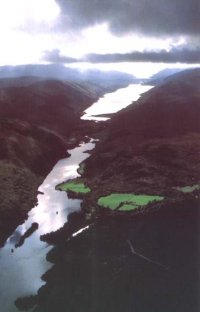
Loch Ness is the largest of three lochs located in the Great Glen which divides the North of Scotland along a line from Fort William to Inverness. The loch is large by British standards, being 23 miles long and a mile in width, and averaging 600ft in depth. Its catchment is hilly and wet, and is drained by 6 major rivers which flow into the loch. It contains over 2 cubic miles of fresh water, and the River Ness outlet, although only 5 miles long, is one of the greatest in Britain for average flow.
Geology
The trench-like feature which contains Loch Ness is ruler-straight and runs SW - NE for over 60 miles across the Highlands. It follows the line of the Great Glen Fault. This fault splits the Highlands from Fort William to Inverness and then goes on Northeast to form the coastline of Ross-shire and Sutherland. Beyond this, it may extend from Caithness to Shetland. Its root has been noted on seismic surveys in connection with the oil exploration of the Moray Firth. The fault is not a simple fault and is complex for 3 reasons:-
(a) It is a transcurrent (tear) fault.
(b) Movement has produced a zone of shattered rock half to a mile wide.
(c) There is also a vertical component with uplift (and erosion) to the north of the fault.
(a) It is a transcurrent (tear) fault.
(b) Movement has produced a zone of shattered rock half to a mile wide.
(c) There is also a vertical component with uplift (and erosion) to the north of the fault.
The fault is a very old feature and has been active since Mid Devonian times (c.400 million years ago). A concensus of the evidence for movement along the fault would suggest that the north moved c.80 miles to the SW (sinistral), followed by an adjustment of c.18 miles in the opposite direction (dextral). This latter firth being out of alignment. With regard to the sinistral movement, much interest has also centred on the similar Foyers and Strontian granites presently 66 miles apart which may have originated as one intrusion.
The shatter belt of rock produced by the fault movement is mostly under Loch Ness, and the ease with which erosion could remove this rock accounts for the wide straight trench of the Great Glen. Shattered rock is very evident in road cuttings by the loch at Castle Urquhart and Foyers. There are deposits of mylonite to the SW of Fort Augustus, proving the heat and pressure produced by the movement.
The shatter belt of rock produced by the fault movement is mostly under Loch Ness, and the ease with which erosion could remove this rock accounts for the wide straight trench of the Great Glen. Shattered rock is very evident in road cuttings by the loch at Castle Urquhart and Foyers. There are deposits of mylonite to the SW of Fort Augustus, proving the heat and pressure produced by the movement.
Earthquakes
The Loch Ness area is still seismically active and averages 3 earthquakes per century at Richter 4. This shows that the fault is still moving and storing enough energy for earthquakes. The epicentres are usually around Lochend and Dochgarroch. Slight damage has been caused by these quakes in the Inverness area. The last notable dates for these were 1888, 1890, and 1901. The most severe locally recorded was that of 1816, strong enough to be felt over most of Scotland.
Solid Geology
The bulk of the basement rock on either side of Loch Ness is classified as metamorphic, mostly schists. Those in the North have always been classified as Moine, mostly psammites and semi-pelites. Originally similar rock to the south were also designated as Moine. However, as modern field-work continues among these metamorphics, they are increasingly being regarded as Dalradian. Thus there could be a 200 million difference in the ages of the rock between the two side of Loch Ness!
Interestingly, the highest point around Loch Ness, the 'sugar-loaf' Mealfuarvonie (2284 ft) is a sedimentary mountain - a residual of Old Red Sandstone conglomerate. These conglomerates are also found on the Foyers side of the loch, and were formed from the erosion of Caledonian metamorphics and igneous rocks along the fault scarp in a desert climate. At that time, Scotland was probably in the latitude of present-day Namibia. Younger sandstones of the Old Red Sandstone are mostly found between Foyers and Dores, with very occasional fossil bands.
Two further areas of interest in the solid geology are the zone of ultrabasic rocks and altered limestones around Glenurquhart, and the extremely fragmented area of rock to the east of Foyers. These may also include faults older than the Great Glen Fault.
Two further areas of interest in the solid geology are the zone of ultrabasic rocks and altered limestones around Glenurquhart, and the extremely fragmented area of rock to the east of Foyers. These may also include faults older than the Great Glen Fault.
Glaciation
The present day Loch Ness is about 10,000 years old and dates from the end of the last Ice Age (which lasted more than 20,000 years). During that age, the Great Glen was occupied by a huge glacier which filled the valley above the level of the present watershed, and extended into the Moray Firth. This glacier found the shattered along the fault easy to erode, which accounts for the great depth of Loch Ness to 600ft BELOW sea-level. The sub-marine sides of the loch are glacially smoothed and very steep. Above Foyers at the deepest section, there is 500ft of water only 60ft out from the bank!
The floor of the loch is remarkably flat and smooth. There is a layer of sediment 25ft deep, and below that, a hard clay which has not been penetrated. So the actual depth of the rock floor of Loch Ness may be much deeper than the 740ft maximum recorded.
At Lochend, the loch is blocked by glacial sediment, and the basin of the loch may extend to Inverness and beyond. Around the sides of the loch, there are many features resulting from the glaciation, such as meltwater channels on the watershed, the gorge at Inverfarigaig, the falls of Foyers, and the peri-glacial screes at Abriachan. Towards Inverness, the melting of the Great Glen glacier gave rise to the kames, eskers, and gravel sheets at Dunain, Phadrig, and Tomnahurich. The River Ness is really a braided glacial river, and Loch Ness - a 'drowned' glacial landscape!
No comments:
Post a Comment